Flag of Lithuania

Flag of Lithuania

Lithuania – a country located in the North Baltic Sea. It gained its unity in the 13th century and became one of the largest states of Europe. In 1569, they merged with Poland.

The flag of Lithuania, just like any other countries in Europe, carries a tricolor of yellow, green and red. It was on March 20, 1989 when it was finally accepted as the country’s national flag, although the earliest flag ever recorded was during the 15th century. The beginnings of the yellow, green and red colors are a result of other European countries wanting to change their flags. It was never known whose idea it was to change the colors of the flag to yellow, green and red. There are instances in which they would point out the idea to come from Lithuanian exiles living in Europe or other parts of the United States.

It is believed that the Lithuanian flag colors had its roots from the country’s national dress but others would like to believe that the yellow stripes represent the sun, green for the fields, and red for the blood that was shed in gaining their independence.

In the early days, Lithuania itself did not have a national flag of its own – what they had was only a state flag. But during the end of the 19th century Lithuania fought for freedom. However, this freedom involved giving them the right to have a government of their own without breaking any alliance with Russia.

After the revolution Lithuania’s longing to have an independent state grew. Of course Russia was aware of this. That is why they thought of a solution to resolve this problem. It was here that the question of having a Lithuanian national flag arose.

At first it was suggested that they use an old flag used by the Duchy of Lithuania. Although some other suggestions came, a commission had to be established in order to resolve the problem of the flag.

On November 11, 1918 the flag was raised for the first time. According to Lithuanian law, the flag should be raised on holidays such as the establishment of the state of Lithuania (February 16), the king’s coronation (July 6) and Constitution Day (October 25).

Mfuwe

Mfuwe

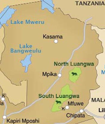
While the South Luangwa National Park is one of the most popular places to visit in the region of Luangwa Valley, Mfuwe serves the caters to the tourism industry in this province. Mfuwe holds an airport that caters to international and local flights especially during the best seasons of the year for the industry.

Tourists and travelers from all over the world come to Mfuwe to visit and experience wildlife safaris. At Mfuwe tourists arrive to begin an adventure of a lifetime and this serves as their first destination. It stands in the middle of a number of great attractions such as wildlife conservations.

The popular accommodations in this place look very simple. Tiny shanties and tent like structures serve as accommodations for tourists. Inside each tent are comforts that any person would love. Most of these tents are good for two while there are also others that are relatively larger. Each morning you can have breakfast while taking in the beauty of the river with the occasional array of animals around it. In the evening, you can relax and watch the sun set. If you feel like staying-up late, there are bars that can cater to your nightcap needs and other forms of relaxation for the best trip you have ever made.


Mfuwe Lodge
Mfuwe
Mfuwe Location on Map Showing

Afghan Afghani

Afghan Afghani

The Afghani is the official currency of the country of Afghanistan with currency code AFN. An Afghani is equivalent to 100 Pul. In addition, 20 Afghani is equivalent to the Amani. The 1st Afghani was launched in 1925. It was meant to replace the rupee at a rate of 1.1 rupee = 1 Afghani. It is still, however, common to hear an Afghan use the word rupee when referring to the Afghani. This should not be confused with the Pakistani rupee for until 1925 Afghanistan’s currency is the Afghan rupee.

Between 1925 and 1993 several denominations of Afghani coins and banknotes were in circulation. Coins issued during this period consisted of 1, 2, 3, 5, 10, 20, 25 pul in bronze, brass, copper nickel, and aluminum-bronze; silver ½, 1, and 2½ Afghani; and gold ½, 1, and 2½ amani. Banknotes issued were in the following denominations: 2, 5, 10, 20, 50, 100, 500, 1000, 5000, and 10000 Afghani. In 1958 bank notes worth 2 and 5 were switched with coins.

Afghanistan’s currency history was marked with a lack of standardization, forgery, and currency revaluation. Before the Afghanistan invasion by the US in 2001, political parties, warlords, forgers, and foreign powers came up with their own banknotes that were tradable. There was no system or standard that was followed. When the Taliban seized government control in 1996, the Taliban’s central bank proclaimed most active Afghan bank notes worthless.

They terminated the contract the previous government had with a Russian firm responsible for printing the Afghani notes in an attempt to eradicate its circulation. The Northern Alliance, however, continued to have notes printed in Russia. These were then sold in the Kabul marketplace at 50% off their value. By this time the Afghani’s value depreciated sharply and by 2001, 1 USD = 73,000 Afghani.

After the U.S. Invasion and the toppling of the Taliban government, a new currency or Afghani was launched in 2002. The new Afghani has no subdivision and replaced the old one at 2 different rates. The ones issued under the term of President Burhanuddin Rabbani were substituted at a rate of 1,000 to 1 new Afghani while those issued by Abdul Rashid Dostum of the Northern Alliance were traded at a rate of 2,000 to 1 new Afghani.

Coins were issued in 2005 at denominations of 1, 2, 5 Afghani. Bank notes were issued in 2002 in these denominations: 1, 2, 5, 10, 20, 50, 100, 500 and 1000 Afghani. In 2005, the 1, 2 and 5 notes were swapped with coins. The new Afghani was valued 43 Afghani to the US dollar and has remained steady with slight movements up to today.


100, 500, 1.000 Afghanis
Afghan Afghani
100, 500, 1.000 Afghanis

Flag of China

Flag of China

The People’s Republic ofChina’s strict communist upbringing is perfectly portrayed by its national emblem – a symbol of courage, boldness, strength and vivaciousness that is predominant in theChineseblood. Living out the Maoist philosophies of life and bringing about a culture that paved the way for economic dominance, military strength and cultural preservation, the Chinese have evidently risen to become a world superpower. With its staggering 1.3 billion people, the challenge of bringing together everyone towards a sense of nationalism and pride in the motherland was a task that China did not discount many years ago.

To materialize the desire to come up with a strong national symbol, the government mandated the Preparatory Committee of the New Political Consultative Conference in July of 1949 to take on the task of soliciting design ideas for the national insignia. A nationwide campaign searching for quality designs that exhibited at least three main components: Chinese components like geography, culture, arts and the like; Power attributes like strength, courage and resilience; and that the color must be dominantly bright red.

After successfully drawing together about 3,000 designs from all over the country, Zeng Liansong’s slightly edited entry was hailed to be the official flag of the great nation. Zeng’s artistic ideas were inspired by an article written by Mao Zedong, Chinese prime leader, national strategist and visionary. The bright red plain was carefully disturbed by five stars – four equal sized smaller stars forming a curve to the right side of a bigger fifth star.

The positioning suggested that the four social classes of China formed a united bond under the Communist Party of China. The stars also could represent the territory of China including Outer Mongolia forming an implication of the Begonia Leaf. After removing the hammer and sickle on the big star as was in Zeng’s original design and much persuasion from Mao himself, the flag was adopted on September of 1949.

Chocolate Hills

The Chocolate Hills are an unusual geological formation found in Bohol, in the Central Visayas region of the Philippines. It is found that there are 1,776 hills spread on an approximate 50 square kilometer area. Depending on the season, the Chocolate Hills change in color, varying from green to chocolate brown.

The Chocolate hills are the most famous tourist attraction in Bohol. The Chocolate hills were featured in the Philippine Tourism Authority’s list of Philippine tourist destinations and are the Philippines’ third National Geological Monument. Proposals to include the Chocolate hills in the UNESCO World Heritage Site list are currently being conducted.

The Chocolate Hills look like women’s dress, or giant mole hills, or something out of a child’s drawing. The unusual thing about it is that it is a natural phenomena! Geologists believe that the hills were formed from marine limestone on top of a clay layer. The Chocolate hills are uniform in shape, some standing from 30 to 50 meters high. They are usually covered with grass the year around, but turn brown during the dry season, thus the name. You can see the magnificent view by climbing 214 steps to an observation outpost above the hills.

You can get to the Chocolate Hills on your own or by joining a day tour. From Tagbilaran, go to the bus terminal in Dao, and take a bus to Carmen. Ask the bus driver to drop you off at Chocolate Hills, located 4 km before you reach Carmen. If you get lost you can always ask help from the locals who are very hospitable and friendly.

The Chocolate Hills is indeed one of the Philippines’ most amazing destinations. The Chocolate Hills Complex has: a hostel, swimming pool, restaurant, and an observation deck to view the amazing hills. You can also view the hills at Sagbayan Peak in the town of Sagbayan.

Panama

Panama

If there’s one country that’d never make you think twice about visiting it, it would be Panama.
One of the most tourist-friendly countries in the world, Panama is very safe and convenient for travelers. It has a low tourist crime rate. That being said, you won’t have to worry about pickpockets while you travel along the streets of Panama. Taxi drivers are honest and courteous as well.

Panama is a perfect tourist destination, especially for Americans. The local currency is the U.S. dollar, so you won’t have to worry about changing your currency when you go there. Your dollar will also go a long way since the prices of accommodation, transportation, and meals in Panama are inexpensive. The country also ranks as the top place for a second home for Americans because of its great attractions, climate, and safety.

People in Panama are warm and friendly because they are used to meeting foreigners every now and then. Most of the natives can speak English, which is their second language. No need to learn Spanish! Panamanians know exactly what Americans prefer and appreciate, so you won’t have a hard time dealing with them. They are fun loving as well. So it’s no wonder why nightlife is very active in the capital Panama City where partying and clubbing are a favorite pastime. The city teems with plenty of discos, casinos, and nightclubs that cater to partygoers.

In particular, the tropical climate in this Latin American country is friendly to travelers. Unlike the nearby Central American countries, Panama has never been plagued by devastating earthquakes or hurricanes. The peak season for tourists is from December to April when the weather is dry and hot.


Map of Panama
Panama
Flag of Panama

The Kunthistorisches Museum

The Kunthistorisches Museum

The Kunthistorisches Museum in Vienna is considered as one of the most important premier museums in the world. It is located near the Hofburg Imperial Palace and is the home of the Habsburg imperial collection.

The Kunthistorisches Museum was erected across the Naturhistorisches Museum and both of these museums are characterized with the same exterior.

The museum was a major museum building in the 19th century. It represents the expansion of the city and is built in the honor of Emperor Franz Joseph I.

The primary collection held by the Kunthistorisches Museum is the comprehensive collection of the Habsburg. The most important imperial dynasty of Austria has a wide collection of art and the construction of Kunthistorisches was intended to make the Habsburg art collection open to the public.

It is home to various collections that are famous in the world.

1. Egyptian and Near Asian Collection. It features a wide collection of Egyptian relics which originated from the Predynastic period of Egypt and dates back to four thousand years ago. It shows the development of the Egyptian culture in terms of history and writing and includes ancient items from the Mediterranean, Mesopotamia, as well as the Arabian Peninsula.

2. Greek and Roman Antiquities. The oldest and the most unique diversity of Greek and Roman ancient items can be found in this collection. Relics of the Bronze Age ceramics to the Early Medieval period are the most important items included in it.

3. Picture Gallery. It is the art collection of the House of Habsburg. It holds various masterpieces of world renowned artists like Raphael, Rembrandt, Velazquez, as well as Italian Baroque painters.

4. Sculpture and Decorative Arts. A unique collection of sculptures and decorations that showcases the extraordinary things that emperor’s and imperial family members have commissioned to find and purchased.

5. The Coin Cabinet. The largest and most important coin collection in the world.

6. The Theater Collection of the Austrian National Library. It is a public library that is home to the extensive book collection of Burgtheater actor, Hugo Thimig. It contains over 90,000 books and references that emphasize art, music, dance, and theater.

The Kunthistorisches Museum is a world class museum that is an experience of culture, history, and the arts in each of its corners.


Kunthistorisches Museum - Sala de bustos romanos (Viena)
The Kunthistorisches Museum
Kunthistorisches Museum - Kouros - VI AC (Viena)

Newry

Newry

The fourth largest city in Northern Ireland, Newry, is popular for its historic border, 67 miles from Dublin, and the center of transactions in Ireland. Located at the Gap of the North, it first became a port until it was made a city in 2002. Since then, it has gained popularity because of its provincial shopping-towns that are at par with the best. The Buttercrane Center and the Quays are worth a visit if you are visiting Newry, Northern Ireland. Even people from Cork, a distant local city, are attracted to these centers due to their attractive prices. Cheaper goods call the attention of shoppers, even making them cross borders.

Because of the expanding popularity of Newry there has been an increase in housing prices throughout the city, with a remarkable increase of 371%. Moreover, its unemployment rate has decreased progressively.

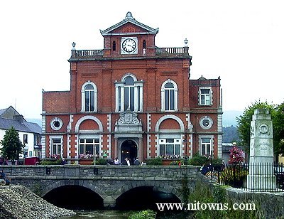
One of the favorite tourist destinations is the Cathedral of SS. Patrick and Colman on Hill Street, which was built in 1829. It is considered as the city’s greatest architecture. The town hall is also a must see, for it has been built over the River Clanrye, a historical boundary that separated Down and Armagh. A museum and arts centre has also held several galleries to prove the eloquence of the arts in the city. The Craigmore Viaduct is an important bridge that is often studied by architects for its construction. The bridge has eighteen arches, the highest of which is 126 feet, stealing the record in all of Ireland. Local granite was the main component of the bridge, expanding to a quarter of a mile.

As a tribute to Saint Patrick, the most important saint in the country, Saint Patrick’s church, the first Protestant church in the area, has been built and been frequently visited ever since. There is also a Roman Catholic Cathedral situated near it bears neo-Gothic architecture. As if to prove the point that Ireland is religiously affiliated, there are many churches in the city that are the subject of tours and crusades.

The River Newry is the most important aspect of the city, with the port and industrial town lying in this area. Much of the transactions happen in the ports, and the business establishments are usually related to the ports. However, the area of industry and architecture are not the only forms of livelihood in the area. There are also sufficient jobs that lure tourists and investors to the area.


Newry postcard post card
Newry
EPC Newry Apartment ?54

Salzburg Old Town

Salzburg Old Town

The old town of Salzburg is a panorama of spectacular beauty and majestic Baroque architecture. It is known as one of the loveliest city in the whole of Europe and is a world heritage site.

It is the birthplace of the famous musician and composer Wolfgang Amadeus Mozart.

Salzburg Old Town is a stunning sight. It sits on the bank of the River of Salzach where the ancient Roman settlements were once located. It is a lovely postcard town. It is one place that can easily be appreciated for its beauty and its location as well as the views that it offers.

In 1997, it is recognized by UNESCO as a world heritage site. The city has strict preservation laws which allow it to maintain its beauty and ardor despite its development.

A walk in the old town allows you to relish its magnificent sites. It is crowned by the Hohensalzburg Fortress which was built in 1077 and is fully preserved until today. The fortress had served as a temporary shelter to prince archbishops and also as a military camp and a prison. Presently the fortress is open to public viewing especially to those who want to travel back in time to this amazing old town.

It is also the location of various churches that offer the best Baroque designs. A walk in the Salzburg Old Town is truly reminiscent of past times, especially because of the beautiful churches that give an ancient feel to it.

What is truly remarkable about Salzburg Old Town is how it manages to preserve the beauty of the city making it a spectacular site for tourists to visit.

This wonderful town is also the location for various parts of the production of “The Sound of Music,” a film by the 20th Century Fox Film Company.


Salzburg Old Town is an
Salzburg Old Town
Salzburg - Wikipedia, the free

Makak

Makak

Nigeria is a beautiful place to see and explore when visiting Cameroon, Africa. Do not think that board and lodging would be a problem since there are hotels, several 5 stars or lower depending on your budget to accommodate you and take care of your needs. So pack your bags and go to the nearest hotels like Yaounde Hotel, Douala Hotel and the Mbalmayo Hotel, to name a few, which is a little far but has one of the best services in the area.

Makak, Cameroon is the town in the central part of Cameroon found on the central province. Tourists often fly to this small area when en route to the other places found in Nigeria. You will find it to be a very interesting place.

The wildlife is amazing here in Makak, Cameroon. You will find a vast array of flowers that can only be found here in Makak. If you take a trip to Makak, make sure to get your mandated immunizations against yellow fever and malaria since you will need proof of having these shots.


Makak czubaty
Makak
Makak Monkey by ~kiezix on

Dommeldange

Dommeldange

Dommeldange is a member of the twenty four quarters in Luxembourg. It is located in the southern part of the country. The town has a relatively small with a population. But despite the few numbers of inhabitants, the area has some surprises in store for every visitor.

The town is surrounded by unending lines of greenery filled with orchards and woodlands. Small villages are also found in the town which has changed a little over the decades. The quiet network of roads that criss-cross along the town allows tourists to explore the whole town on foot. Exploring by foot allows more interaction with the surroundings, making visitors appreciate the town and all that it has to offer.

The town is characterized by low rainfall and a relatively warm climate. Winters are mild and summers are warm, reaching to 35 degrees Celsius at the highest. The town also enjoys a sunny atmosphere during most parts of the year.

The Luxembourg Railway Station also has a station in Dommeldange, making it very accessible. Transport to nearby places is also an ease through the train. Aside from transportation, the railway is also known for its magnificent architecture employing Baroque style. The railway is being quickly modernized, but its medieval look is expected to be maintained.

Dommeldange is one of the many places to discover Luxembourg; its people, culture, and history. The town is easily reachable by air since it is near major airports. Excite yourself in a whole new experience offered by Dommeldange.


Dommeldange
Dommeldange
Dommeldange Station in the

The Canadian Rockies

The Canadian Rockies

The collection of mountains that extend to the parts of British Columbia and Alberta is the Canadian Rockies. These mountains are layered by sedimentary rocks. Its peaks are spiky because of glaciers on it. These glaciers obviously make the mountains cooler and moist.

There are five major parks that are part of the Canadian Rockies, they areYoho, Jasper, Kootenay, Banff and Waterton.

The oldest park of Canada and one of the most visited parks around the territory is Banff. Some of Banff’s residents include Grizzly bears, lynx, deer, weasel and a many others. Next is Jasper, the largest of the five. It is also in Alberta and at the West of Edmonton. The park is alluring because of glaciers, lakes, hot springs and many more.

The Kootenay National Park’s main attractions are the Hot Springs, the Olive Lake, the Marble Canyon, Sinclair Canyon, Floe Lake, Fay Hut, and also to mention the Paint Pots –a spring rich in minerals. Yoho National Park lies in the South of British Columbia. Limestone caves are found here.

Obviously, there are a lot of places to explore in the Canadian Rockies.


The Canadian Rockies
Gateway to the Canadian

Divrigi Great Mosque & Hospital

Divrigi Great Mosque & Hospital

A mosque and a hospital may seem like an unlikely combination for some people. However, visiting the Divrigi Great Mosque & Hospital in Anatolia, Turkey would show travelers that a combining a place for spiritual and physical healing makes perfect sense.

The Divrigi Great Mosque & Hospital is one of Turkey’s famous spots. Built in 1299, the structure boasts of elaborate carvings that exhibit the people’s skillfulness. It was Mengujukid Emir Ahmet Shah who commissioned the construction of the mosque. At the same time, his wife—Melike Turhan Melek—commissioned the construction of the hospital in the same complex.

Declared as a UNESCO World Heritage Site, the Divrigi Great Mosque & Hospital is Anatolia’s oldest complex. Made of yellow stone, the structure is a sight to behold. The eight-sided domes only add to the magnificence of the place. Travelers would be impressed with the view of the complex from afar, but visiting the structure and seeing the details up close is a far greater experience.

The two parts of the Divrigi Great Mosque & Hospital each have its own charm. The mosque houses a single prayer room topped with two cupolas. This takes up most of the complex, and is larger than the hospital. The northern doorway is considered as the main entrance to the mosque, and is higher than the other parts of the mosque. The carvings are ostentatious, and feature dedications to Sultan Aladdin Keykubad and Ahmet Shah, who built the complex.

The hospital is smaller, but that does not mean that it is less striking. In fact, the hospital’s carvings are more refined. Among these carvings are moldings featuring human figures that stand for the moon and the sun.

Visiting the Divrigi Great Mosque & Hospital is like unlocking a secret, as the place is not crowded with visitors. Visitors would do well in visiting the site now, so that they can say that they’ve been to one magnificent place that not many people have gone to.


Great Mosque and Hospital of
Divrigi Great Mosque & Hospital
Divrigi Great Mosque

Alaska Zoo

Alaska Zoo

If you are looking for a place to visit which will surely be enjoyed by the kids and the adults, you should visit the famousAlaska Zoo. Located in Anchorage, it is easily accessible with minimal to no traffic drive. You can easily find it on a map or you can just even ask directions from the locals. It is important to call the information center of the zoo before your visit to inquire if they will be having special events or to check the operating hours so you will be able to maximize your visit and enjoy it to the fullest.

The zoo serves as shelter to many of the animals. Here you will get to see the wildlife with your very eyes. Their bears are one of the most famous animals to the visiting tourists, most especially to the foreign ones. Polar bear, grizzly bear, glacier bear, you will get to see them all. Aside from the very touristy attractive bears, there also are the other members of the animal kingdom which are worth seeing and getting to see up close as well. It is not only going to be all sightseeing, you will also definitely learn more about the animals and your eyes will be more opened as to why you should be even more caring to the environment.

Alaska Zoo is definitely one place to visit if you want to get closer to nature and to get acquainted with animals you haven’t seen before. Make sure to drop by the zoo, most especially on holidays, because the zoo has beautiful presentations during those times. It is advisable to wear your most comfortable clothes and shoes to freely roam around the area. There are already available areas where you can eat and shops where you buy souvenirs as well.


The Alaska Zoo
Alaska Zoo
Alaska Zoo Coupons are great

Novgorod

Novgorod

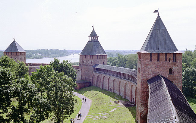
When going to new places, especially out of the country, one of the things you look for really is beauty, and not just the comfortable sensation of being away from the office or your home. You want to walk through parks at night and zoos and gardens during the day. You wish to visit museums and gaze at historical artifacts, if those interest you, or simply appreciate paintings, sculptures and other forms of art in an art gallery. When visiting Russia, your eyes cannot leave the place unsatisfied, especially if it’sNovgorodyou step into.

Novgorod, also known as Veliky Novgorod (literally “The Great/Big New City”), is North-Western Russia’s foremost historic city. It is the heart of the Novgorod Oblast’s administration. Its current population is over 200,000.

Novgorod is unlike other Russian or Ukrainian cities in terms of medieval monuments. The best-preserved of the eleventh century churches is the St. Sophia Cathedral, constructed between 1045 and 1050 under Vladimir Yaroslavich (son of Yaroslav the Wise)’s patronage, likely the oldest structure in Russia which is still in use, and the first one to represent Russian architecture’s original features. Traditionally referred to as the Detinets, the Novgorod Kremlin houses the oldest palace in Russia (the Chamber of the Facets), the oldest bell tower and clock tower in Russia.

Three large churches stand outside the Kremlin walls. The St. Nicholas Cathedral contains frescoes of Mstislav the Great’s family and graces the former chief square of Novgorod, Yaroslav’s Court. The Yuriev Monastery is one of the oldest monasteries in the country. A three-domed cathedral similar to that contained in the Yuriev Monastery was built in the Antoniev Monastery on the orders of its founder, Antonii. Some fifty other medieval and early modern churches are scattered about the city. The greatest early Novgorod architecture masterpiece is the Savior Church situated at Nereditsa.

Traveling to and around Novgorod isn’t complicated as it has many connections to the country’s two largest cities, Moscow and St. Petersburg, via the federal highway M10. You can take the railway route or ride a trolleybus or bus to your other in-city destinations.


The history of Novgorod is
Novgorod
Moscow Novgorod and St

Issyk Kul Lake

Issyk Kul Lake

Travelers who have an interest for adventure tourism will be delighted to have Issyk Kul Lake as part of their itinerary. This lake is one of the main tourist attractions in Kyrgyzstan, a republic in Central Asia which won its independence with the breakup of the Soviet Union in 1991. The lake is the 10th largest in the world in terms of volume and is endorheic, meaning it has no outflow to the ocean or sea. Its Kyrgyz name “Issyk Kul”, translates to “warm lake”. The locals call it this not because its waters are warm but because the lake never freezes despite being surrounded by snow-capped mountains whose glaciers actually feed it with water. The lake is in the eastern part of Kyrgyzstan in the province that is also named Issyk Kul, with Karakol as its capital.

One source of delight for visitors is that they would in fact be tracing part of the ancient Silk Road interconnecting trade routes between the Asian and the European continents. Historians say that Issyk Kul Lake was one of the stopovers of traders who took these routes for over 3,000 years since prehistoric times. Among the traces of that these ancient travelers left was an Armenian monastery ca. 14th century, found on the lake’s northeastern shores. Underwater archeologists have also discovered at the lake’s bottom lots of artifacts and structures indicating that a metropolis with an advanced civilization flourished at Issyk Kul when the water level there was very much lower some 2,500 years ago.

A popular vacation destination during the Soviet era, Issyk Kul Lake visitors dwindled after the USSR breakup. But tourism is again picking up. An increasing number of tourists are now again flocking to Issyk Kul to enjoy swimming and sunbathing at the many beach resorts surrounding the lake, as well as challenge their stamina trail-hiking in the surrounding mountains.


around Issyk-Kul lake
Issyk Kul Lake
On the Issyk Kul lake.

Eisriesenwelt Caves

Eisriesenwelt Caves

If you are looking for a different thrill with the most astounding natural scenery that you can find, the Eisriesenwelt Caves in Werfen, Austria will capture your heart as an amazing limestone ice cave.

The Eisriesenwelt Caves is a natural ice cave in the Salzburg area. The caves are open from the 1st of May until late October. It is the biggest ice cave system in the world and is known to cater to most tourists in the midst of the summer heat.

Its name suits its exploits best. Eisriesenwelt literally means the World of Ice Giants and indeed it is. The mountainside caves of Salzburg is known for the largest ice formations and the wonderful view of these formations will surely make you feel amazed at the beauty that nature offers on this side of Austria.

It was discovered initially by a natural scientist named Anton Posselt. It was known to the locals as the gateway towards hell which is mainly the reason why no one dared to enter the caves during that time. In 1880, upon Posselt’s discovery of the caves, he published a report that was soon forgotten by the community.

It was Alexander von Mörk, a cave specialist and explorer, who remembered Posselt and his discovery. He started the explorations in the mountains which were followed by the others. Later, when the first routes in the mountains were created, the caves soon rose to fame as tourists began to flourish in the area.

A tour in the Eisriesenwelt Caves is worth every second. From the entrance, the tour will be directed to the Posselt Hall towards a big room with a stalagmite formation named the Posselt Tower. Then, it continues inward where a cross marker can be seen as the sign of the farthest area that Posselt reached in his exploration.

Large ice formations will follow soon after that point. The area where the largest and tallest ice growth can be found is named the Great Ice Embankment. Next to it lays the Hymir Castle where a formation of stalactites called Ice Organ or Frigga’s veil is located. Frigga is a Norse pagan goddess and is the wife of Odin.

Inside the caves, you will also find one of the largest areas called the Alexander von Mörk Cathedral. It is the resting place of the ashes of Alexander von Mörk and indeed, the rightful place where his remains should find its place.

Exploring the ice caves of Eisriesenwelt will be such a delight. Wear warm clothes and trousers in order to battle the coolness of the caves but most of all, enjoy the amazing ice formations which feature the spectacle of nature at its best.


Travel to Eisriesenwelt Caves
Eisriesenwelt Caves
The Eisriesenwelt Caves is a

Suez Canal: Important Waterways

Suez Canal: Important Waterways

The Suez Canal is the most important and known waterways that is situated in Egypt. It was opened in the year 1869 and its purpose was to allow transportation of water between Europe and Asia. All this is done without plotting a course around Africa, the Mediterranean and Red Sea. The total length of the canal is 193 kilometers (120 miles). The canal is 24 meters (79 ft) deep at maximum depth. The width of the canal is 205 meters (673 ft). It has 3 lanes with four passing places like great Bitter Lake, Mediterranean, and Gulf of Suez on the Red Sea. The owner of the Suez Canal is Suez Canal Authority (SCA) of Arab Republic of Egypt.

The Suez Canal is considered to be very important oil transit chokepoints from the Red Sea to the Mediterranean Sea. The Suez Canal is also responsible for almost 8% of shipping traffic, with more than 50 ships taking a voyage through the canal daily. During the year 1967, the canal was closed because of the Six Day War. The canal has become a source of fighting as it serves as a buffer zone for Israel. The canal was reopened in the year 1975 and since then, it has been widened two times.

From the tourist perspective, one must aim at traveling around the Cape Agulhas. This route is supported for ships that are too large and huge in size. This is also the safest route, as piracy in Somalia is increasing day by day.


The Suez Canal is undoubtedly
Suez Canal: Important Waterways
One of the most important

Umayyad Mosque in Damascus

Umayyad Mosque in Damascus

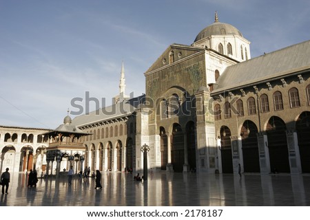
The Umayyad Mosque in Damascus, Syria is one of the oldest and the largest mosques in the worlds. It is known for its intricate architectural beauty. Sometimes, it is also called the Grand Mosque of Damascus. The elegant color combination with the lighting makes the mosque even more beautiful. The tomb stands in a garden that is adjacent to the wall of the mosque. The mosque holds a memorial and contains the head of John the Baptist, who is said to be honored as a great prophet and preacher by both Christian and Muslims.

Damascus is said to be the oldest colonized city in the world and the mosques is located on the land that is considered the most sacred ground. The mosque has been created for over 3000 years starting in 1000 BC, on the same ground, a temple was made for Hadad, who happens to be the god of storm and lightening. In the north east corner of the mosque a sphinx has been discovered.

A huge Temple of Jupiter was built over the Aramean Temple by the Romans in the 1st century AD. The temple was made on a raised rectangular platform with square corners on all four sides. It was during the 4th century that the temple became a church. The temple was broken and a church was built and was dedicated to a Baptist called John. The Muslim took over the Damascus in 636; however, it did not affect the church. The building today is shared by both the Christians and Muslim Pilgrims.


Umayyad Mosque
Umayyad Mosque in Damascus