Arusha

Arusha

Located in North Tanzania, Arusha is the city closest to the masterpieces of Nature. It is situated just at the foot of Mount Meru, which is at the east side of the Great Rift Valley. This city is very near to Tanzania’s major geographical and wildlife attractions.

Though it is very near the equator, Arusha enjoys a cool and dry climate. This is because of its 1400 meter average elevation from sea level. The average temperature is 25 degrees Celsius all year. The region has a distinct rainy season which is usually at April and May.

The city has a very beautiful, mountain side landscape. With Mt. Meru on the north, Arusha has a smooth down hill slope as one goes south. Hundreds of thousands of tourists visit the place per year. It has its own Arusha National Park located on the mountain.

The city also serves as the base for people wanting to visit Mt. Kilimanjaro, the Ngorongoro Crater and the Serengeti National Park. These places are inhabited by plenty of game species like lions, birds, gazelles, rhinos and zebras. People who enjoy the sight of rich flora and fauna consider Arusha as their primary destination.

For less than an hours ride, people can also visit the anthropologically rich Olduvai Gorge. There are museums displaying recovered artifacts from early humans and hominids.

At the end of the day, there are several top-rated lodges to choose from: the Impala Hotel, Mount Meru Hotel, Onsea House and more. There is also the famous Dik Dik Hotel which organizes mountain climbing parties to Kilimanjaro.


Arusha National Park poster
Arusha
Arusha Market

Merowe

Merowe

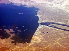
Merowe, Sudan is home to the famous sand hills and the intently guarded Merowe necropolis, and ancient burial ground or cemetery that has such an interesting history it’s often referred to as city of the dead. Merowe is another very important tourist destination in Sudan, located in the eastern bank of the Nile River, and 200 kilometres from Sudan’s capital, Khartoum.

The railways are the most important mode of transportation to this city, and buses and Lorries are often used by tourists to get around town.

Other than the historic and intriguing necropolis, the major of attractions of this place are the Temple of the God of Amun, and the Great Enclosure of Pyramids. Currently, the Merowe Dam is getting a lot of attention as well. It’s a US$1.8 billion project being built on the Nile of Sudan. It’s bound to produce hydropower for the area and it’s a controversial project because it will be displacing about 5000 people from near the Nile, to arid desert areas.

Merowe is dotted with about 200 very magnificent looking pyramids. Most people link pyramids with ancient Egypt, but those huge rock piles are actually copies of the original pyramids in Merowe, Sudan. The pyramids here are much smaller, as if designed to contain only one dead body per structure.

Merowe is home to some of the friendliest and most hospitable people on earth called the Nubians. They’re great to tour Merowe with, especially when going to see the great pyramids. An old temple and infinite sand also encompass the pyramid area and the great burial grounds of Merowe.


Merowe Dam
Merowe
Manu Ampim - Merowe Dam

Mary

Mary

Most people seldom consider Turkmenistan as a travel destination especially during the summer season, the problem is; they may just not know where to go. The bone-dry climate of this country in Central Asia can be attributed to the many deserts therein, specially the Karakum Desert. But did you know that there is a real life “oasis” in this region?

An oasis is usually depicted in movies and novels as a hallucination a person sees when he is the desert and suffering from heatstroke, to the Turks, that is exactly what the city of Mary is like. This city is known by the names Merv, Meru and Margiana and is the capital of district. It is located along the Murghab River in the Karatum desert that is why it is a literal oasis.

Visitors that come here often visit the Regional Museum that hosts the artifacts of the ancient city that once stood in its place. It provides some sort of sanctuary for travelers who are not accustomed to the hot weather and dry winds.

As a part of Turkmenistan, Mary’s cultural diversity proves just how rich a region it is. The areas of the city also cater to farm land for cotton and cereals. There is a reserve for natural gas which helps the country’s economic stability.

The travel getting to Mary may be a tiring and hot one, considering it is located in the desert, but it will certainly be worth it once you get to experience a true modern oasis.


More Mary:
Mary
Blessed Virgin Mary, Our Lady,

Baishui Terraces

Baishui Terraces

Regarded as a sacred site to the Dongba culture and an extremely popular attraction where the Naxi people live, the Baishui terrace holds a sacred beauty. A place where literary pieces and sacred rituals have been made. There are many visitors who have been captivated by the beauty of the Baishui terrace, found on the foothills of the Haba snow mountain in Shangri-La.

Ideally visited during spring, summer, and autumn months, the land where the Baishui terrace is located has an indeterminate temperature which changes rapidly from time to time during the day. From afar, and especially during autumn months, the crystal like terraces look like a white precious marble overflowing with water against a contrast of trees and blooming flowers from the mountains.

An annual holiday is held during the eighth day on the second month of the lunar calendar. Singing, dancing and various rituals are done in order to pay tribute to the founding father of the Dongba religion. Visitors are allowed to watch and take part in the ceremonies.

When visiting the Baishui terrace, it is advised that visitors a lot a minimum of a two hour period to trek along the foothills of the Haba mountain and enjoy the beauty of the terrace. It is also advised that visitors bring extra clothes and rain gear because rapid temperature changes occur during the day and rain is expected to pour at any given time.

Visitor packages are available which will mostly cover attractions near the Shangri La area; most of these packages include a two hour tour to the Baishui terraces. Peak seasons are during spring, summer, and autumn. Hotel and accommodation is easily available although they might get quite crowded during peak season. Mobile phone signals and internet connection are already available although signal strength might get weaker when in mountains or in gorges.


Baishui Terraces
Baishui Terraces
Baishui Terrace @ Shangri-

Old Havana

Old Havana

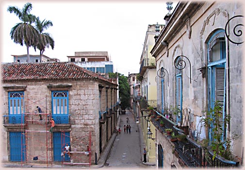
If you want to travel back in time to an earlier destination, a trip in an old city would do. Old Havana in Cuba is a breath-taking place, composed of various old infrastructures. The city of Havana originated during the year 1519, along with the prosperity of Galleon trade. The city is located near the bay, so the treasures of Spanish Galleon ships were continuously brought in there. Because of this, the city prospered and many infrastructures were built in neoclassic and baroque style. These structures have been well, preserved making Old Havana a trip to the ancient world.

Old Havana is famous for its old fortresses, churches and buildings which are as follows:

* There are four old fortresses which still stand nowadays. These are the Castillo Los Tres Reyes Del Morro, La Cabaña, San Salvador de la Punta and Castillo de la Real Fuerza. La Cabaña is the most famous above all because of its magnificent structure.

* There are two historical churches that are popular among tourists, the Cathedral de San Cristobal and San Francisco de la Habana Basilica. The two churches are built between 17th and 18th century in baroque style of architecture.

* The Plaza de Armas is an open space or square built initially for military ceremonies. Currently, this is where tourists stay for a wide view of the old city.

* The Gran Teatro de la Habana, also known as the Great Theater of Havana, is well-known for the performances of National Opera and National Ballet of Cuba.

* The Museum of the Revolution is famous for its artifacts from the rich history of Havana.

Old Havana was inscribed in the UNESCO World Heritage List in 1982 because of the city’s preservation of ancient structures. Tour buses are now available for tourists in order to have a look on every old buildings of the city. Various tour companies are around offering trips from place to place; this is convenient rather than exploring the city alone. Appreciate history and have a time travel like vacation at Old Havana.


Old Havana is the stopping
Old Havana
Hotel Inglaterra in Old Havana

Trinidad Info

Trinidad Info

Trinidad is the capital city of Beni, Bolivia. It has a population of more than 100,000 inhabitants. It is situated at a 237-meter altitude above sea level, which is 14 degrees latitude at the south of the equator. The climate in Trinidad is humid and tropical although it is generally hot all throughout the year. Trinidad’s temperature ranges between 22C and 28C or 71F and 83F. During summer, rainfalls can be experienced, with most of it occurring in the winter.

You can get to Trinidad either by land, air, or river. If you are coming from Santa Cruz, it would be 550 km by asphalt and rubble road. If you are coming from La Paz, it would be 595 km by asphalt road. If you opt to use the river, you can take the Guayaramerin City as a disembarking port fro Puerto Villaroel, which is situated in the Chapare region of Cochabamba. On the other hand, you should know that Trinidad is not located near riverbanks. It may take 3 to 10 days if you opt your trip from Puerto Villaroel to Guayaramerin City.

Some of the main attractions in Trinidad, Bolivia include the following:

• Sanctuario Chuchini – This main attraction includes prehistoric works from Paititis, which is believed to be over 5,000 years old.
• Laguna Suárez – This main attraction is a huge artificial lake that is 5 km from Trinidad.
• Loma Suárez – This main attraction is an artificial mount that is 9 km from Trinidad.
• Puerto Barador – This main attraction boasts of pink river dolphins as it is located along the Momore river shores.


Trinidad info - Mission Trips
Trinidad Info
Trinidad & Tobago Info

Liechtenstein

Liechtenstein

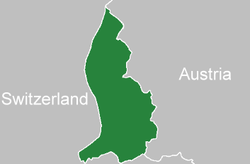
Liechtenstein is a small state in Western Europe and it is also close to the borders of Austria at the east and Switzerland to the west. It covers an area of about 160 square kilometers and the population here is about 38,720.

Liechtenstein comprises of 11 municipalities and it is also the world’s smallest German speaking nation. The majority of the lands are cultivated and the surrounding areas are mountainous and these areas are one of the best winter sports destinations.

Liechtenstein has an altitude of about 2599 meters and it is also the world’s sixth largest independent nation. The 11 municipalities in Liechtenstein are Balzers, Eschen, Mauren, Planken, Ruggell, Schann, Schellenberg, Gamprin, Triesenberg and Vaduz the capital of Liechtenstein.

Liechtenstein was established into a small nation around 1719 AD and later it in the year 1806 it formed as a sovereign state. At the time of World War I it was close to Austria and the economic condition of the nation was collapsed due to the low taxes. In the present days Liechtenstein is one the peaceful countries in the world and it has no enemies among the other nations. Also it emerged as one of the major tourist spot, the major attractions here are

Museum of Fine Arts
It is located in the Vaduz city and the museum covers an area of about 1750 square meters. It houses the collection of contemporary arts, rotating exhibits and the collections of Liechtenstein Prince.

Liechtenstein National Museum
This museum features 42 exhibit halls and it houses the collection of the natural, cultural and national history.

Calculator and Typewrite Museum
This museum features the collection of a number of objects of about 150 years old. The collection includes the legendary Curta and the world’s smallest mechanical calculator.

Gutenberg Castle
It is a free standing castle located on the top of 70 meter high rock. The castle has its history from the 13th century and it also played a key role at the time of Bronze Age.

Vaduz Castle
The Vaduz Castle was built around 700 years ago and it is also the official residence for the Liechtenstein princess. In the present days it is one the major attractions in the Vaduz city.


Location of Liechtenstein
Liechtenstein
Flag of Liechtenstein

Placencia

Placencia

Located along the coastline of Belize is the long and narrow peninsula that is called Placencia, Belize. This area has three populated areas which are the Maya Beach, the Seene Bight and Placencia Village. You can choose from any of these three villages where you may want to stay since each one gives you many different activities and options for fun on the sand and surf here.

To get to Placencia Belize, you will need to book yourself a flight on either Maya Island Air or Tropic Air. You can also choose to get to this peninsula by way of bus, which will take you four to six hours from Belize City along rough and dusty roads. If you do not want to brave this very long and dusty trip, you can also choose to fly in from the south of Belize.

There are many things you will enjoy doing in Placencia, Belize and these include the many beach activities that people usually enjoy as well as the exploration of the unspoiled regions of the area. You can visit the Placencia Lagoon and indulge in some wildlife watching and bird watching there. You can also go river rafting, kayaking and canoeing in this lagoon. Snorkelling, jungle tours, reef diving and fly-fishing are also other activities you can indulge in while here. If you want a change in pace from all these nature adventures, take some time off from them by hanging out at one of the coffee shops located along the main street of Placencia, Belize.


Placencia Village to Water
Placencia
Placencia Snorkeling

Colosseum Location

Colosseum Location

Considered to be one of the greatest contributions of the Roman Empire to the world, theColosseumis visited by millions of travelers all across the globe every year.

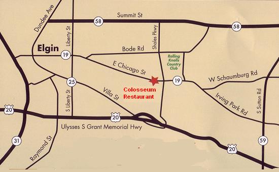
But if you plan to go to this famous landmark, you probably need to know the Colosseum location.

The Colosseum is in Rome, Italy. It is located in the central-western part of the Italian Peninsula with a latitude of 42 degrees (North) and longitude of 13 degrees (East). The Leonardo da Vinci Airport is quite a ways from the Colosseum at nearly 22 km away. However, the Colosseum is just a little over 5 km from the Vatican.

This favorite tourist destination has become part of the busy city. A trip to Rome will not be complete without paying a visit and experiencing an ancient yet world-class tourist destination.

Transportation

When you visit the Colosseum, you may take a taxi from the airport. The Colosseum is about 22 kilometers from the Leonardo da Vinci Fiumicino Airport.

There are different modes of transportation when moving around Rome. You can rent your own car, use the Public Transit bus service that run 24 hours a day, the metro service line, and taxi services.

There are hop on, hop off buses which stop at this famous landmark to accommodate visitors and tourists.


Colosseum Restaurant Location
Colosseum Location
Colosseum Location

Taj Mahal Tomb

Taj Mahal Tomb

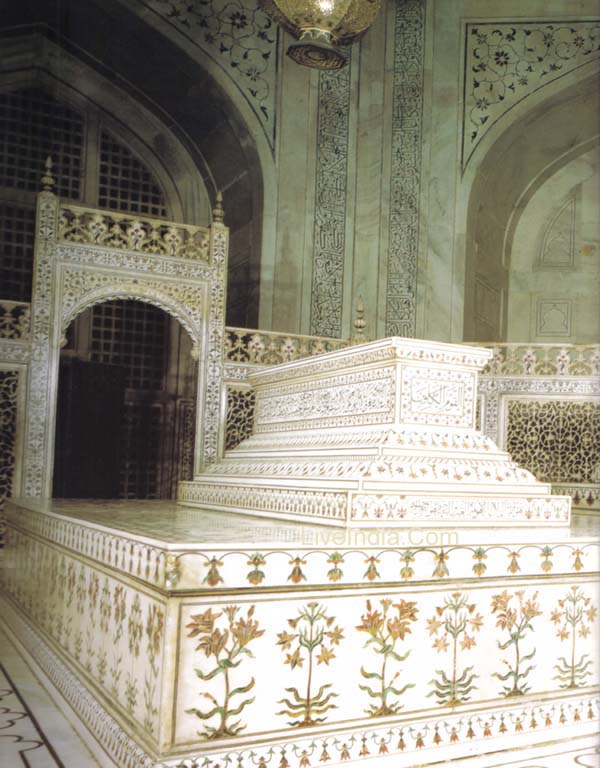
The stunningTaj Mahalin Agra, India, is among the most stunning architectural achievements in history. Although its primary function is that of a mausoleum, the structure is actually a complex with a variety of functions.

The Tomb

The heart of this palace-like structure is the Taj Mahal Tomb, which contains two exquisite cenotaphs representing the occupants of the tomb, Shah Jahan and his wife Mumtaz Mahal. A cenotaph is tomb which is empty and meant to represent the people who have been interred. The actual bodies of Shah Jahan and his wife are buried beneath their cenotaphs in a lower chamber. Both cenotaphs are elegantly carved and inlaid with semi-precious stones.

Shah Jahan was the emperor of the Mughal Empire. He began building the Taj Mahal in 1632 upon the death of his much beloved wife Mumtaz, who died giving birth to his 14th child. It took nearly 20 years and thousands of workers to complete the Taj Mahal and the magnificent tomb – all of it in memory of Mumtaz Mahal.

The Taj Mahal tomb itself is basically a cube-shaped structure measuring about 180 feet per side. It has chamfered corners and it topped by a large dome and “moon-cusp” finial. The whole structure sits atop a square plinth and has an arch-shaped doorway, called an iwan.

The Dome

The onion-shaped marble dome surmounting the structure is a marvel in itself. It’s about 115 feet high, which is the same as the length of its base. This is perched atop a cylindrical column about 23 feet high. At the top of the dome is a lotus design. Smaller domes positioned at the corners of this primary dome design create a pleasing symmetrical effect.

At the top of the dome is a finial spire thrusting an upturned crescent moon toward the sky. The moon cusp is a common Muslim motif. When first built, the finial was covered in gold, but is plated with bronze today.

You might say that the Taj Mahal Tomb is a work of architectural brilliance within a work of architectural brilliance.


TAJ MAHAL TOMB DETAIL
Taj Mahal Tomb
38 Taj Mahal Tomb,

Sandanski

Sandanski

Named after a Bulgarian revolutionary who was instrumental to end of the Turkish rule in Macedonia, Sandanski is known for its dazzling spa resorts. Sandanski is surrounded by the Bistritsa River valley where the air is said to be the cleanest in Europe. The town also has the best climate in Bulgaria with its long hours of sunshine, not to mention its hot springs with temperatures ranging from 33 to 83 degrees Celsius. No wonder, Sandanski is well loved by international visitors who crave the fine summer heat, invigorating air, and relaxing atmosphere.

Once you step into Sandanski, consider yourself lucky because you can head over to the only four-star hotel in town: the Hotel Sandanski. Pamper yourself with massages, wellness treatments, hot spring baths, and other relaxing spa packages that the hotel offers to tourists.

Shopping in Sandanski as just as relaxing. Take a stroll down Macedonia Avenue, the main shopping street in Sandanski, under the shades of trees. Many art galleries can be found in Macedonia Avenue, so get your pocket ready for some fun shopping spree.

While you’re in Sandanski, don’t forget to visit the popular landmarks in the greater Sandanski area. These attractions include the breathtaking Rila Mountains, the sandstone pyramids in Melnik, and the hot springs in The Rupite volcanic crater.

For tourists who find pleasure in relaxation and sightseeing, Sandanski makes the perfect holiday getaway.


Sandanski Park Hotel �Pirin� �
Sandanski
Map of Municipality SANDANSKI

Flag of Zimbabwe

Flag of Zimbabwe

Zimbabwehad to struggle against at least two colonial powers, Great Britain and Rhodesia, to claim its well-enjoyed independence since 1980. It first made its way out of Britain’s colonial sphere in 1965 and was considered as Southern Rhodesia for the next 15 years until the nation finally managed to free itself from colonial rule. The rich African culture of theZimbabweanswere adequately preserved and continued despite the layers of foreign occupancy. This preservation is evidenced by their chosen motif for the independent country’s emblem.

The flag has a triangular area on its left side, where the pole is normally nearer. It has a white background with the soapstone bird featured on a red star. The white triangle shows a period or area for peace in the land. The bird symbolizes the history and culture of the people and the red star under it shows the country’s relentless struggle for liberation and peace. To its right are seven equally wide bars of colors showing traditional African schemes. The top and bottom-most bars are green which depicts the agricultural and rural areas of the country. Beside both green stripes are the yellow ones which show the wealth of mineral deposits in the country as mostly connected to gold. The two inner bars of red portray the massive bloodshed in the conduct of the first and second wars towards independence. Ultimately, the single black stripe in the middle shows the African heritage that is inherent in the ethnic background of the country.

The Zimbabwe flag carries very notable signs of African heritage which can be seen in almost all states that enjoy independence from their original colonial masters. The varieties of colors are believed to include the hues that sprung from the Ethiopian flag to celebrate its longest reign as an independent African state.

Staples Center

Staples Center

TheStaple Centeris fairly new, having been built in 1998 and opened to the public in 1999. The center is home to 3 basketball teams (theLos Angeles Lakers, Los Angeles Clippers, and the Los Angeles Sparks) and 1 hockey team (theLos Angeles Kings). One can buy sports memorabilia from Team LA, which is the official store in the Staple Center which sells everything from basketball jerseys to sports jackets.

A handful of important sporting events, award shows, and concerts have been hosted at the Staple Center over the years. Celebrities and singers such as Justin Timberlake, Britney Spears, Lionel Ritchie, and Cher have graced the stage during their concerts or world tours. Even the world-famous singing competition show, American Idol, has used the center as a stop for auditions, and the concerts and tours of the contestants.

Up to now the Staple Center is still used as a location for concerts, sports competitions, conventions, and other important events. The most important rule to get into the center is to arrive early. The center can seat up to 20,000 people, so one can imagine the throng of people waiting outside if they arrive late. There are also 20,000 parking spaces near the center, so if one wants to get a good parking spot, he/she has to arrive early.

It is highly accessible to those with limited mobility. Guide dogs and other service animals are allowed inside, and wheelchairs can even be stored while the customer is inside. There are parking spaces for disabled visitors, and wheelchair escorts are on hand to assist visitors who require wheelchairs. Three exclusive restaurants are located in the center where one can eat a full course meal if he/she doesn’t want to eat hotdogs or drink soda. For those who need quick food fixes, fast food outlets and snack stops are also in the center.


Staples Center
Staples Center
STAPLES Center

Belizean Dollar

Belizean Dollar

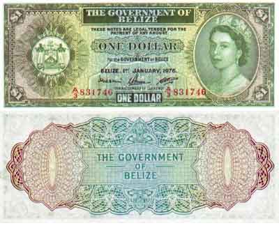
The Belize dollar (BZD) is Belize’s national currency and is pegged at the U.S. dollar at 2 BZ$ is to 1 US$ since the 1980s. U.S. dollars are generally accepted throughout Belize because of this peg. It is considered a waste of time to exchange USD to BZD when it is supposed to be used inside the borders of Belize. Belize dollars are also easily accepted in towns outside but close to the border of Belize. Inside the Corozal Free Zone in the Norther border inside Belize, only U.S. dollars and Mexican pesos are accepted.

In 1885, 1 cent bronze coins were introduced by the government. In 1894, the silver 5, 10, 25, and 50 cent coins followed. This same year, the government issued 1, 2, 5, 10, 50 and 100 dollar notes. After 1928, the 50 and the 100 dollar notes were stopped. In 1952, the 20 dollar note was introduced to the people of Belize. By 1990, both of the 50 and 100 dollar notes were in circulation again. The 1 dollar note has been replaced by a coin.

The Belize dollar and all coins of Belize are printed at Thomas De La Rue Ltd. All banknotes of Belize feature Queen Elizabeth II; Belize being a member of the British Commonwealth; the Queen being the Head of State. The 1 dollar note has an underwater scene printed on the back side and a stork on the front. The 2 dollar note shows the Mayan ruins of Belize and a fauna. The 5 dollar shows the medallion of Christopher Columbus and St. George’s Caye. The 10 dollars shows buildings of Belize. The 20 dollars shows the animals of Belize as well as a jaguar. The 50 dollar note shows bridges of Belize, a boat and a rental fish.

As Belize banks offer usual rates of 2.0175 dollars for a U.S. dollar, one may find ‘peseros’ or money changers all throughout Belize offering relatively low rates. A visitor who wishes not to fill out long forms and stand in long lines inside banks may want to have the exchange with these local money changers. While these ‘peseros’ are tolerated, the authorities may advise against them.


Belize Dollar (BZD) Banknotes
Belizean Dollar
Belize 2 Dollar 2005

Jokhang Temple

Jokhang Temple

April to October are the best months to visit the Jokhang temple since the weather is pleasantly mild during this period. Harsh weather conditions occur during the later months. In addition, if you want to avoid the crowd and want to save money, winter months are the best times of the seasons to make a visit.

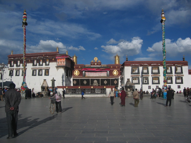
The Jokhan Temple, which means ‘House of the Lord’, is the holiest site in Tibet and is a primary destination for monks. The temple was built in 746 by King Songtsen Gampo. Moreover, the present structure is the result of a reconstruction done by the fifth Dalai Lama in the 17th century.

Nepalese and Indian architectural influences are prevalent in the Jokhang temple. The temple features a golden roof with wood patterns and carvings.

The thousand meter long Tibetan mural is a must see when visiting the Jokhang Temple. It has a depiction of Princess Wen Cheng’s procession and arrival in Tibet. Precious cultural relics are also being kept and preserved in the temple which make it a good place for research about Tibetan culture and history.

Jokhang temple’s most prized and oldest object that sits in the central hall is the statue of twelve year old Sakyamuni. The sculpture was carried by Princess Wen Cheng herself. The statue of Sakyamuni is gilded and adorned with precious jewels.

Lhasa’s weather is humid, visitors are advised to wear light clothing. Caution is advised by bringing extra clothes in the event of a sudden downpour, which sometimes occurs during the day. Bringing enough cash for the trip is also advisable since ATMs are quite hard to find in Tibet. Visiting on festival days is recommended. This allows a visitor to be immersed in the Tibetan festivities and experience more of their culture.


Jokhang Temple
Jokhang Temple
File:Jokhang Temple in Tibet.

San Andres Island

San Andres Island

San Andres Island is situated in the Caribbean Sea. It forms an archipelago together with its neighbors, small islands that line the coast. These islands are more popularly known as a single unit, named the Archipelago of San Andres, Providencia and Santa Catalina, with San Andres Isl., Colombia as its capital.

Archipelago of Wonders

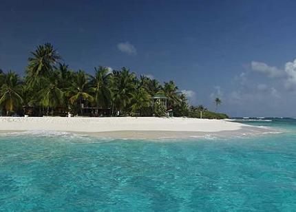
The Caribbean Sea is always a great idea for a tourist destination. But the Archipelago of San Andres, Providencia and Santa Catalina offers more reason to visit this side of Latin America, bringing more life to the Caribbean region. Those who are looking forward to diving in crystal-clear water brimming with breathtaking marine life, playing and swimming in white-sand beaches, enjoying an exciting nightlife, and learning a whole new culture will not be disappointed when they stop by in this part of Colombia.

San Andres Isl., Colombia boasts of a rich, colorful, multi-ethnic history, owing greatly to its geographical circumstances. Thus, tourists can expect a vivid cultural experience, ranging from the cuisines embraced (made up mostly of fish and vegetables, with coconut, breadfruit, plantain, and spices as accents) to the languages spoken (mainly different dialects of Spanish and English). And the experience won’t be complete without music. Here, everyone takes it all in with beats of salsa and reggae in the background. Suffice it to say that San Andres, along with all its neighboring islands (including the Bolivar and Albuqueque islets, the Crab cays, and the Alicia and Bajo Nuevo sand banks, to name just a few), offers the opportunity to create fun, lasting memories.

An Array of Activities

There are plenty of things to do when in San Andres Isl., Colombia. For sightseeing, a walk up El Cliff allows for a pleasant stroll for a great view of the coral reefs and the whole town. There are natural wonders to discover, including the El Hoyo Soplador (a sea water geyser that can only be seen under certain conditions), Islote Sucre (a white-sand beach that has tropical vegetation), and the La Cueva de Morgan (a constantly enlarging sea cave). Of course, a trip to the island won’t be complete without water activities. Cocoplum Bay has gentle beach slopes and shallow water perfect for swimming. SpratBright, a tourist favorite, has excellent waters and boat rentals for viewing marine life and exploring nearby cays. Divers can check out the ruins of the sunken ships Blue Diamonds and Nicaraguanse.


San Andres Island, Colombia
San Andres Island
San Andres Island beaches.

Bodrum

Bodrum

Much like most cities in Turkey, Bodrum has a rich history. Records show that inhabitants settled in the city as early as the 7th century BC. Formerly called Halicarnassus (or Halikarnas in Turkish), the city now thrives in a combination of old world charm and modern vibrance.

It is no surprise that travelers hold a special spot for Bodrum once they visit the city. There is something quite endearing about the place, and such makes it an ideal destination for vacations. There are a handful of interesting places in the city that are worth a visit.

The Mausoleum at Halicarnassus is among the famous spots in Bodrum. The structure, which was constructed between 353 and 350 BC, is considered as one of the Seven Wonders of the Ancient World. The city’s ruler, Mausollos, had a wife—Artemisia—who wanted a resting place for her husband when they met their demise. The structure exhibited the craftsmanship of the sculptors then. Today, the Mausoleum at Halicarnassus is still that imposing structure that never fails to leave travelers in awe.

The Castle of St. Peter is also quite a wondrous sight. This castle in Bodrum was built in 1400, and served as a refuge for knights for a long time. Constructed near the Mausoleum at Halicarnassus, the Castle of St. Peter used materials from the former. Today, the structure is home to the Museum of Underwater Archeology. Visitors can find out about the city’s history by visiting the museum.

An open-air museum can also be found in Bodrum. The Ampitheatre—divided into three parts namely the skene, orchestra, and cavea—is testament to the people’s skill in architecture during the ancient times. Built between 330 and 30 BC, the theater could seat 13,000 people. The structure dates back to the time of Mausollos, and its glory is still preserved today.


Bodrum Milta Marina
Bodrum
Bodrum - Bodrum Castle also

Erdenenmandal

Erdenenmandal

Arkhangai aimag is one of the 21 aimags of Mongolia. It is surrounded by other aimags namely Bulgan, Bayankhongor, Khövsgöl, Övörkhangai, and Zavkhan. A small town situated in the northern part of Arkhangai province is Erdenenmandal near Tsetserleg.

Because this aimag is surrounded by different aimags, you can travel and go sightseeing from one place to another. Their main economy is agriculture and raising domesticated animals such as goats, horses, sheep, and cattle.

While in Erdenenmandal, you can go to the small market just around the area for your basic needs and supplies. Fuel for vehicles such as diesel and gas are hardly available. Because of this, there are times that vehicles and public transport is not available. A small central post office with a phone line can also be found within the area.

Erdenemandal is a migratory place for nomads living in the farthest parts of aimags and other provinces during the harsh winter conditions. They set up their gears and yurts to protect them from fierce winds and snow which can go down from −30 to −38 degree Celcius.

Rivers you can visit nearby include Chuluut, Tamir, and Khanui rivers which are all tributaries of the Selenge watershed. A lake is found on the west part of the town, Terkhiin Tsagaan Nuur. Legends say that the lake was created when a giant threw a huge rock on a water passage which eventually formed the lake and they called the rock that was said to have landed on the farther east of the aimag Taikhar Chuluu.


Bogdkhan Uul Strictly
Erdenenmandal
A landlocked country between