Kermanshah

Kermanshah

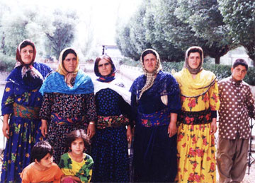
Kermanshahis a city that borders both Iran and Iraq. This area is mostly mountainous and has a colder climate than most other cities in Iran. This is a very diverse city since it lies near the borders of both Iraq and Iran. Aside from Iranians, many people live here including Muslims, Assyrians, Jews, Yarsan and Armenians. Most of the residents here are Shia Muslims though.

Since Kermanshah is very diverse, the sites here vary from Mesopotamian, Greek, Roman, Zoroastrian and Islamic origins. Here are a few examples of these:

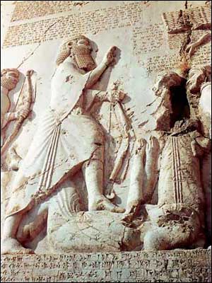
The Behistun is the ultimate symbol of Kermanshah’s diversity. The Behistun, UNESCO World Heritage Site, is a large limestone wall that has multi-lingual inscriptions in it. These inscriptions are Babylonian, Elamite and Old Persian. It is 15 meters high and 25 meter wide. It also has a bas relief image with Darius the Great, Persian Emperor. Another example a Persian monument here is the Taq-e Bostan. The Taq-e Bostan is a large grotto of an equestrian figure of King Khosrau II in his stallion Shadbiz.

A Muslim monument found in Kermanshah is the Mo’acenalmolk Mosque. This mosque is beautifully crafted and features unique Persian touches. In its wall, you will see the Shahnameh, the National Iranian epic, depicted in art. It also contains Islamic images. The Khaja Barookh House is a Jewish monument here. It is a house in the Jewish neighborhood of Kermanshah, built by Barookh, a Jewish merchant.

Kermanshah is a culturally-diverse Iranian destination that’s definitely worth visiting.


Iranian Cities: Kermanshah
Kermanshah
From Kermanshah the road runs

French Guiana

French Guiana

Located in South America between the countries of Brazil and Suriname, the French Guiana is an overseas area of France. Exploring the French Guiana can be quite an adventure. The country is home to a diverse mixture of cultural backgrounds due to its rich and colorful history. There are many things to do in French Guiana, such as experiencing the authentic cultures, observing many protected species of animals, exploring Devil’s Island, panning for gold, and canoeing down majestic rivers.

Devil’s Island is a controversial location to visit while in French Guiana. It is the smallest and northernmost island of the three Iles du Salut located off the coast. It has an area of 34.6 acres and was used by France as a prison between 1852 and 1946. It was considered one of the most infamous prisons in history. Because of its location, other than boat, the only way to escape was through the harsh dense jungles, which very few managed to accomplish. Many of the buildings are still there to remind you of how harsh the conditions of the prison were.

French Guiana has several carnivals to enjoy while visiting there. King Carnival starts after Epiphany and goes on until Ash Wednesday. And like many other cities with a heavy French influence, they have a large Mardi Gras celebration, with the towns almost all painted red for the parade of red devils.

French Guiana has an equatorial climate, so it is advised to dress cool and dry. The weather is warm and humid with little variation in temperatures throughout the year. The annual average is 27°C. The dry season takes place during the months of August thru November and the rainy season is between December and July.


locator map of French Guiana
French Guiana
Map of French Guiana

Groningen

Groningen

On the northernmost part of the Netherlands, you will find the city of Groningen. The city was founded in 1100 A.D, it’s in this city that you will be able to catch a glimpse of the old world merging in with the new. This city is considered to be a university town so you can expect to find a younger crowd roaming the city streets. If you can, try to plan out your Groningen holiday in time for their annual festivals dedicated to the arts, film, music and theatre.

Going on a bike tour is probably the exciting and economical way that you can experience the city of Groningen. Simply join a guided tour in English and you will get to see all the important sights in the city and at the same time have an intensive work out as well. Though it’s easy to get intimidated by the huge amount of bikes that you will see on the streets, you should make sure that you keep your own bike secure, as bike theft is quite rampant in this area.

As soon as you enter the city of Groningen, the first thing that you should do is visit the Martinitower. The church dates back to the 12th century and has miraculously withstood the most devastating wars of the past century. Be sure to climb up all the way to the tower so that you see a spectacular view of the whole city.

Because the city of Groningen plays host to thousands of students from major universities such as Rijksuniversiteit Groningen, the city’s nightlife is always alive and kicking, no matter what time of year it is. Clubs, pubs and coffee shops are abundant in this city so be prepared to make friends with some locals and party all night. You will be able to find some good eating and drinking places that will fit your budget. Just head on to where the crowd is going and you’re bound to find the coolest places to hang out in the city.

Groningen may just be the Netherlands’ equivalent to the city that never sleeps. So start planning your getaway to Groningen.


Museums in Groningen
Groningen
Exterior view - NH Groningen

Flag of Egypt

Flag of Egypt

TheEgyptian flagconsists of three equal horizontal red along with color white and black bands of the Arab Liberation flag since the Egyptian Revolution of 1952. The Eagle of Saladin, Egypt’s national emblem, is centered in the white band. Egypt’s flag today was adopted on October 4, 1984.

The Free Officers whom King Farouk lost to in the Revolution of 1952 designated specific symbolism to all of the three bands of the Arab Liberation Flag. The color red represents the period before the Revolution. It was a time described by the skirmish against the monarchy and the British occupation of the nation. The white on the other hand represents the peaceful nature of the Revolution. The black represents the halt of the cruelty of the people in Egypt at the hands of the foreign colonialism and monarchy.

The use of Egypt’s Arab Liberation flag triggered the inspiration of other Arab nations. The similar horizontal tri-color is used by countries like Iraq, Syria and Yemen that is formerly known as Libya. The only dissimilarity is the presence of the recognized ensigns and emblems on the white band.

The Muhammad Ali Dynasty was the one who determined the transformation of the modern Egyptian flag. It was the era when Egypt was united with Sudan and later by the Arab nationalism on their rise.

The flag of Egypt is hoisted on all Governmental buildings on the end of the week (Fridays) and national holidays, opening sessions of the People’s Assembly and other occasions declared by the Minister Interior. The flag is hoisted daily on borders, other official buildings and the embassies along the overseas on Revolution day on July 23 every year. Abusing the flag is a criminal offense and is punishable by law as it implies mockery of power of the nation. Penalties are provisioned and it governs the abuse of flags from other nations.

Philae Island

Philae Island

Philae is an island in the Nile River with rich vegetation, lovely flowers and magnificent temples. Because of its beauty and abundance, it was rightfully once called the ‘pearl of Egypt’. Philae derived its name from the Egyptian ‘Pi-lak’, which the Greeks later changed to ‘Philai’, while the Arabs called it Bilak.

Indeed, the island was once regarded as one of the most romantic and most beautiful places in Egypt. Yet, due to constant floods of the Nile River, the island lost much of its attraction. The island was in great danger of being submerged due to the floods since the construction of the Aswan High Dam. The flooding situation is so bad that temples are only accessible in the island during late summer and fall. For the rest of the year, the temples are mostly under water. The more important monuments of the island were transported and rebuilt in the adjacent island of Agilkia, which are more highly elevated.

Now, the grey discoloration of the walls and columns are merely a faint reminder of the vibrant colors and detailed ornamentation they once had. Once you arrive at the island, pillars and papyrus capitals, and a pylon with a collection of reliefs of Ptolemy XII smiting his enemies will welcome you. Beyond the gateway, you will find the Mammisi Birth House and the Temple of Isis, where in the middle a golden statue of Isis once stood; and the interiors heavily decorated with images of the goddess. Further on, you will find the Kiosk of Trajan, Philae’s most prominent monument.

The magnificent temples of Philae are open during summers from 7 AM to 5 PM, and in winter from 7 AM to 4 PM. You can reach the island by boat, where they drop the visitors at the Hall of Nectanebo.


Philae Island, now submerged
Philae Island
Isis at Philae island in

Port de Paix

Port de Paix

If you want to get out of and want to be able to relax and enjoy with some peace and quiet, visitPort-de-Paixin Haiti. This major seaport was once named Valparaiso or Vallee du Paradis by Christopher Columbus and the Spaniards. The people of Port-du-Paix are very much friendly, and exude that famous Creole hospitality. They do not join the political unrests and are very much business-minded people. Majority of the population is into entrepreneurship, and they have a sense of leadership and independence as well. Their culture is very much strong and the people are very proud of what they have achieved as a community. Majority of the famous artists, intellectuals, writers and poets come from the city of Port-du-Paix, so do not miss the chance of checking this area out when you are in Haiti.

While it is seldom visited, this town boasts of many buildings that have wonderful architecture that can compete with those of the other cities in the country. You can reach Les Cayes via air or boat depending on what suits you best. Flights to this area normally come from Port-au-Prince. One of the best hotels in the country can be found here in Port-de-Paix which is the Rival Hotel. The rooms are very spacious and can give you a fantastic view of the Caribbean ocean. The weather in Les Cates is perfect for any outdoor activity such as walk tours, swimming at the beach or windsurfing with friends.

If you have your heart set on a Caribbean getaway for the summer, do head on to Port-de-Paix for a one of a kind experience that you will surely treasure and share with your friends when you come back home.


Port-de-Paix (Port of
Port de Paix
Port de Paix from above

Zimbabwean Dollar

Zimbabwean Dollar

The Zimbabwean dollar was the official currency of Zimbabwe from 1980 to April 12, 2009.  Due to political turmoil and the collapse of the economy, the Zimbabwean dollar with currency code ZWD (symbol: Z$) is no longer in circulation.  Instead, standard trading currencies used and accepted today are the US dollar and South African rand.  The UK pound, Euro, and the Botswana pula are also generally accepted.

On April 18, 1980, The Republic of Zimbabwe gained independence from former British colony Rhodesia.  As a result the Zimbabwean dollar was issued to replace the Rhodesian dollar at par value. At that time, the Zimbabwean dollar was higher in value against the US dollar at 1.59.  However, since then political turmoil, hyperinflation, and the collapse of the economy has severely devalued the Z$ making it one of the weakest currencies in the world.

By 2008 inflation rates peaked at 80 billion percent a month.  That’s 6.5 quindecillion novemdecillion percent a year–or 65 followed by 107 zeros!  Simply put, this means that inflation was at 98% a day and that prices of basic commodities doubled every 24.7 hours.

The Z$ underwent three re-denominations in 2006, 2008, and 2009.  For up to July 2008, a Z$100 billion banknote can only purchase 3 pieces worth of eggs.  On July 30, 2008, the Reserve Bank of Zimbabwe redenominated Z$10 billion to Z$1.  Coins were subsequently issued with and valued at Z$25, Z$10 and Z$5; banknotes, on the other hand, were issued and were valued at Z$5, Z$10, Z$20, Z$100 as well as Z$500.  On the 2ndof February, 2009, another redenomination made the Z$1 trillion equivalent to Z$1 new (4th edition).  New bank notes were introduced again at Z$1, Z$5, Z$10, Z$20, Z$50, Z$100 and Z$500.  These currencies remained legal tender and circulated together until June 30, 2009.  During this time 1 US dollar was trading above 300 trillion Zimbabwe dollars.

In January 2009, the use of foreign currencies was legalized.  This move led to a sharp drop in the usage of the said currency.  By April 12, 2009, the Zimbabwean dollar was abandoned as an official currency.  According to the Zimbabwe government, they will only reintroduce the dollar if industrial output would average 60 percent more of its current output capacity as compared to the April 2009 output of 20 percent.


The First Dollar (ZWD)
Zimbabwean Dollar
The First Dollar (ZWD)

Pakistani Rupee

Pakistani Rupee

Rupee is also the currency of the country Pakistan. In order to distinguish it from other rupee countries, like Nepal and India, it has the code of PKR; its sign is Rs. In Pakistan, the rupee is also called as “rupaya” or “rupaye”. The central bank of the country, the State Bank of Pakistan, is the one in control of issuing the currency.

The word rupee came from a Sanskrit word rūp or rūpā, which means silver. That was introduced between the year 1540 and 1545 CE. The Pakistani rupee was circulated in 1947, after they were independent from the British Rule. After a few months from their independence, Pakistan used Indian coins and notes – stamping it with the words “Government of Pakistan” in dual languages, English and Urdu. Denominations of these notes were 1, 2, 5, 10 and 100 rupee.

Of coins, during 1948, denominations made were of 1 pice, ½, 1 and 2 annas, ¼, ½ and 1 rupee. One pie coins were added in the fifties. In January 1961, the rupee was subdivided into 100 pice (the word later changes to paisa and in English, paise). During the 1960s, 1, 5 and 10 pice were issued after which it was renamed to paisa. The 2, 10 and 25 paise were introduced in 1963. One paisa coins were last produced in 1976. The 5, 10, 25 and 50 paise were discontinued in 1994. Introductions of the 2 rupee and 5 rupee coins were made in 1998 and 2002. There are two versions of the 2 rupee coins, some have clouds printed above the Badshahi Masjid and a lot don’t have it.

For the banknotes, the government regularly issues 1, 5, 10, 100 rupee in 1948. The 1 rupee note was discontinued in the eighties. Another issuance of notes was made by the State Bank in 1953, with 2, 5, 10 and 100 rupees notes were issued. Added in 1957 were the 50 rupee notes followed by the 500 rupee in 1986 and 1,000 rupee the next year. The 2 and 5 rupees notes were replaced in the form of coins in 1998 and four years later. The following additions were also made: 20 rupee notes in 2005 and 5,000 rupees in 2006. All the banknotes (except for the 1 and 2 rupee) have the image of Muhammad Ali Jinnah on the obverse. The reverse side has the translation of Prophet Hadith – “Seeking honest livelihood is worship of God.”

Haji notes were also printed due to numerous Haji pilgrims to Saudi Arabia in the 1950s. They stopped circulating in 1978.

As of February 23, 2011 the exchange rate was 1.00 Pakistani Rupee = 0.0117 U.S. Dollar.


Pakistani rupee - Currency
Pakistani Rupee
Pak Rupee

Tokmok

Tokmok

Many travelers ought to overlook the beauty of Central Asia. Tokmok, Kyrgyzstan, for example, has various undiscovered sceneries that you wouldn’t want to miss. The city of Tokmok is found in the northern part of Bishkek, the capital city of Kyrgyzstan that has an altitude of 816 meter above sea level. The main spot of Tokmok is instituted in the middle of Chui Valley where three destinations can be witnessed.

The first one is the ruins of Ak-Beshim. This archaeological site has many buried artifacts that consist of Uyghur scripts and Sogdian inscriptions from the Kyrgyz ancestors. Archaeologists will surely get a hold on to this and look for the evocative remnants themselves. Next is the long-standing Burana Tower. The moment you enter this building, you can see an exceptional winding stairway with uneven textured wall. With over 40 meters high, this structure is still mounted by tourist even if it received significant damage from earthquakes. The story behind this tower is like the Rapunzel tale, with a staircase; plus, a little bit of Sleeping Beauty’s chronicle. The king’s daughter was locked in this tower to save her from death by her 18th birthday. However, the witch’s admonition still came true when a poisonous spider bit her despite seclusion.

Kyrgyzstan has never been commercialized nor visited by tourists because of its unfamiliar tourist spots. But right after reading this, you might change your mind and make it known to the world by sharing the beauty you discovered in Tokmok, Kyrgyzstan.


Tokmok Photo
Tokmok
Tokmok Location Map

Shibaozhai Temple

Shibaozhai Temple

The Shibaozhai Temple showcases fantastic old world scenery that makes tourists feel like actors in a fictional adventure flick. This 100-foot high red pagoda stands in front of a mountainous area full of shrubs and trees, with a glorious backdrop from afar. The addition of the Yangtze River near the 12-tiered temple completes the look of a mysterious wooded area on the face of the planet.

The attention-grabbing pagoda is the main attraction of Shibaozhai Temple. It has two areas: the upper part and the lower one. The upper part is located near the temple buildings that serve as extensions, while the lower section is a nine-level structure adjacent to the rock extension. Traditional Chinese designs mark the exteriors of the pagoda, with various elements of nature. The structure is inspired by the mountains, with patterns and figures that vary from odd to extraordinary.

Shibaozhai was erected in some time during the Qing Dynasty when Emperor Kangxi ruled the land. Shibaozhai means Stone Treasure Fortress, which fits to its very exotic location. The temple protects several artworks like paintings and sculptures that dated back during the Three Kingdoms period. On the top of the temple lies an exquisite view of the river and its nearby town.

Visitors of the temple can climb up the pagoda stairs to experience the spectacular sight from above. Although the stairs in the temple are steep, tourists who want to go up can take an exit route that can be found outside the pagoda. Its stairs are more spacious and less steep than the stairs inside the temple.

If you wish to visit Shibaozhai Temple, cruise ships on the Yangtze River allow its passengers to take a walk in the area and climb the pagoda.


Shibaozhai Temple 400
Shibaozhai Temple
Shibaozhai Temple (3

Moorea

Moorea

Moorea is said to be the ideal honeymoon destination in the planet. This high island from the French Polynesia territory lies a few kilometers shy of northwest Tahiti. You would probably find this place often featured in wedding magazines and other websites meant for traveling couples.

In Tahitian, the name Moorea literally means yellow lizard. There are other names of which this island is referred to such as York Island and Aimeho. One of the most fascinating facts about this island is that the entire area resembles the shape of a heart. However, this is not necessarily the reason for this place to become honeymoon central.

There are many reasons a tourist would find this place very attractive. It offers a great view of the sea and the island is filled with trees. The sea breeze is constant which makes your stay very cool and comfortable even as you walk under the sun. There are a number of different resorts which offer great facilities to cater to your every need. There are many activities being offered such as snorkeling, hiking and other water-related leisure interests. If you seek relaxation at its finest, there are spas which offer various treatments to soothe all the stress away.

Practically speaking, the most enticing feature of Moorea would be the accommodations. There are some cottages which are built just on top of the reef. You can have the full view of the island and the sea from your window. There are also some rooms or cottages which offer great facilities inside. This would also include a glass floor which will enable you to see the marine life and the beautiful coral reef just beneath your floor. There is much to see and a long list of things you can do in this island where you can have the privacy you need while you enjoy every moment of your stay.


Moorea island is a high island
Moorea
Moorea is only 11 miles from

Sequoia National Park

Sequoia National Park

A famed U.S. national park, it is one of the foremost tourist destinations in California. The Sequoia National Park is located in the southern part of the Sierra Nevadas east of Visalia. It gets its name from the famous giant sequoia trees that are spread out all over the park. The sequoia tree is one of the largest trees on earth.

The Sequoia National Park is divided into two parts, the front country and the back country. The front country is made up of blue oak woodlands, chaparral, grasslands and yucca plants. Along its foothills abundantly lives different wildlife. You can see mountain lions that have found recluse in this part of the park. The lions co-exist with other wildlife, like foxes, squirrels, rattle snakes and bobcats. The higher elevation of the front country is covered with greeneries from rare species. The back country, on the other hand, is almost covered with wilderness. It offers a vast area of high-alpine wonders.

However, this is the area where you can rent rustic tent cabins and eat meals prepared by gourmet cooks.
The park offers variety of activities that can be undertaken by the whole family. Bonds are strengthened through camping, hiking and fishing. Unique experiences are also offered by the park – the tunnel log where cars can drive through a fallen sequoia log; crystal cave that joins the two parks; the crescent meadow that is popularly known as the gem of the sierra; and Moro rock that offers breathtaking views of the park.

The Sequoia National Park is United States’ premier visitor destination. It is also one of the best locations for family outings. Not only does it allow communing with nature, it also fosters long lasting bond through its tranquil surrounding. One can never really appreciate nature until he experiences a day or two in the park’s forest, because this is where you can really experience wildlife coexist with men.


Sequoia National Park
Canyon National Parks -

Nitra

Nitra

In western Slovakia, you will find a great city to explore, Nitra. This is located at the end of the Zobor Mountain at the valley of the Nitra river. The place has an estimated population of about 85,000 and it is the fourth largest city in Slovakia. It is also one of its oldest cities and had the distinction of having the earliest seat of political and cultural events. Because it is located at the north temperate zone, the climate is continental and it experiences four seasons. It is located at the warmest part of the country.

So where do you go about when traveling in the city? First on the list, make sure that you visit the Grand Seminary at Pribina’s Square. There are various religious structures that you can view within the area such as the St. Emmeram’s Cathedral; there is also a Piarist church and religious congregation with Roman Catholic influence that was founded by Saint Joseph Calasanctius.

Even if you are not the religious type, you will get a feast out of good architecture and sights that can fill up your cameras and travel blogs. There are various castles and structures that can be seen in the city that greatly showcase how rich its history and past have been. As you roam about, you can also take a peek at various museums to view the galleries and learn from the artifacts that are proudly displayed at these spots. This will truly be an enriching and amazing experience that will create a great impact on you.


Nitra. facts in brief
Nitra
History of Nitra

Tarangire National Park Info

Tarangire National Park Info

Wildlife, sceneries, nature itself—these are the things offered by Tarangire National Park. It is a popular wildlife national park of Tanzania. After Mkomazi, Katavi, Mikumi, Serengeti and Ruaha, Tarangire is the sixth largest. It is home to several game species like elephants and lions. It is also perfect for bird watching. It has more than 550 species of birds—the most number in one place compared to all other regions in the world.

The Tarangire National Park is about 2,850 square kilometers wide. It is can be reached by 75 mile trip, southwest from Arusha city. People can experience on-foot Safari exploration with expert guides. Other than wildlife, visitors can also explore the culture and arts of Barabaig and Maasai tribes. The place is also rich anthropologically, with plenty of ancient rock paintings.

People can visit the national park anytime in the year. However, it is best to have a safari trip from June to September. These are the dry months. The number of species is highest in this time of the year. The animals gather at the most abundant water source during dry time, the Tarangire River.

Bird watchers will enjoy the huge number of game species in Tarangire. On grounds farther from the river, there are ostriches and Kori bustards, the heaviest flying bird. One can also see tree climbing lions and huge pythons coiled on the trees as well. There are herds of about 300 elephants too.

Inside the National park, there are hotels known for their good services and delicious food. Some of them are the Tarangire Sopa Lodge, the Swala Camp and the Tarangire Safari Lodge.


Serengeti and Masai Mara
Tarangire National Park Info
Serengeti National Park map

Ajanta Caves

Ajanta Caves

Ajanta caves, the magnificent Buddhist rock-cut caves in India are located 101 kilometers away from Aurangabad, Maharashtra. It is a renowned name in the world of architecture and is listed as a world heritage site by UNESCO in the year 1983. These caves were created in the 2nd century B.C. and is comprised of thirty caves along with paintings and sculptures of respective era. The caves are shaped from the volcanic lava of the Sahyadri hill.

John Smith, a British captain, discovered these caves in the year 1819 accidentally while hunting in the forest. The caves provide a different and unique combination of art and architecture. Paintings discovered inside the cave were made between the fifth and seventh century. Most of the paintings revolve around Buddhism. The reason behind establishing these caves was to provide a religious prayer place for Buddhist monks. The Chaitya hall and the Vihara hall are the best preserved Buddhist architecture which were located in different caves.

The caves are open from 9:00 in the morning to 5:00 in the evening; please note that on Mondays the caves are closed. The entrance fee varies for different tourists coming form different countries. The best way to reach the caves is through flight or train. As it is located at 100 kilometers away from Aurangabad, a person can return to Aurangabad by catching either a flight or a train which are present in plenty.

Ajanta caves, a well defined example of ancient age is full of life with the collection of murals, paintings and sculptures. I suggest the readers to visit these wonderful caves if planned a vocation in India.


The Ajanta Caves � Ancient
Ajanta Caves
The Ajanta Caves � Ancient

Hagar Qim

Hagar Qim

Hagar Qim is a massive megalithic temple complex that dates in between 3600-3200 BCE. Located on the island of Malta, the temple complex is a masterpiece and one of the world’s major religious sites. In addition the Hagar Qim is also listed in the UNESCO World Heritage Site.

The temple is situated on the top of a hill and was built using globigerina limestone which is also Malta’s second oldest rock. The temple features two massive rocks at the entrance and it also features a massive wall and forecourt.

The temple complex features a main temple and three other additional buildings. Built between 3600-3200 BC the entry at the outer block features six massive chambers and the wall here is built of large stones. The main sites in the complex are:

Temple Forecourt
The temples forecourt features irregular slabs in front of the outer wall. The floor features large blocks of stones and floor here looks similar to the forecourt in Mnajdra’s southern temple.

Dwelling Houses and Bastion
The dwelling houses are a group of small sized stones. The bastion here borders the temple with massive stone blocks. The wall here is about 20 meters long and it features a massive stone that weighs about 57 tons.

Northern Temple
It is the oldest block in the temples complex. It features a secondary doorway and three layers of flooring. In addition a number of stone balls are seen on the walls and also these balls serve as the foundation for the temples complex.

Women’s Chamber
The Women’s Chamber features a rectangular slab and a stone pillar. The chamber features an Oracle hole which is used for transmitting sound in those days. In addition the remains of several blocks can also be seen in the present days on this site.

Main Temple
The temples entrance measures about 14.3 meters long with massive slab walls. The temples interior is entirely different compared to the temples of that period and it features stone altars and smooth blocks. These objects were discovered in the year 1839 and it can be seen at the Valletta museum.

The Watering Place
It is situated on the top of a hill close to the temples complex. It features seven reservoirs where three rivers consist of water and the remaining are dry.


Hagar Qim Temple, Qrendi
Hagar Qim
09 - Huge menhirs at Hagar Qim

Dazu Rock Carvings

Dazu Rock Carvings

This is the home of exquisitely carved and beautiful rock carvings, where a journal of a rich past is displayed. The influence of Taoism, Buddhism, and Confucianism are found along the steep hills of the Dazu County. Dazu County is located south east of Sichuan province, which is known for its warm climate.

The county hosts forty sites of the world-renowned rock carvings where there are fifty thousand statues of Buddha included. The Dazu rock carvings became known for its artistic and exquisite demonstration of rock carving skills. This has made it a part of the Cultural Heritage List in 1999 together with other well-known rock carvings from other countries.

The rock carvings are found beginning in Dazu County to Baodingshan, Beishan, Nanshan, Shizhuanshan, and Shimensan; all of which are adjacent to Dazu County.

Baodingshan rock carvings are approximately fifteen kilometers northeast of Dazu County. There are a total of almost ten thousand figures categorized into thirteen carving groups with a strong influence of ethnic Buddhism.

Beishan rock carvings, on the other hand, are situated two kilometers northwest of Dazu County. Buddhist philosophy is reflected in each of the well-preserved statues and when it comes to elaborate and graceful craftsmanship, the ‘Oriental Venus’ or the Samantabhadra Bodhisattva stands out.

Nanshan and Shizhuanshan are both located south of Dazu County. At this location, a combination of Taoist, Buddhist, and Confucian influences are being integrated making a rare piece of rock carving that stands out among others.

Shimenshan is located twenty kilometers east of Dazu County where the carvings are more of a combination of Taoist and Buddhist influence. Most statues possess inscriptions about the statues.

During the summer months, Dazu County gets quite warm that it becomes unsuitable for most tourists. Spring, autumn, and winter months are ideal times to make a visit. The rock carvings are open for viewing from 9:00am to 5:00pm.


Dazu rock carvings
Dazu Rock Carvings
Dazu Rock Carvings

Okapi Wildlife Reserve

Okapi Wildlife Reserve

At 1,372,625 hectares, the Okapi Wildlife Reserve covers around one-fifth of the Ituri forest in the northeastern part of the Democratic Republic of Congo. The reserve was established to protect the high diversity of species, especially those endemic to the Ituri forest. The animal from where it derived its name, the okapi (Okapia johnstoni), is the only living relative of the giraffe. It looks like a stumpy short-necked giraffe and has stripes on its rear legs similar to those of the zebra’s. The reserve is home to around 5,000 okapis. The reserve was listed as a UNESCO World Heritage Site in 1996.

Aside from the okapis, the Okapi Wildlife Reserve is also home to around 4,000 elephants, 2,000 leopards, 300 species of birds, thirteen species of primates including chimpanzees, three species of crocodile, and other animals of the rainforest like the forest buffalo, water chevrotain, forest elephants, insects, and antelope. It is in fact also one of the important sites in mainland Africa dedicated to bird conservation. Its human inhabitants belong to the Mbuti and Efe pygmies who are considered to be one the few remaining “forest people” of the world.

Other than witnessing the culture of these people and seeing the wild animals in their natural habitat, visitors to the Okapi Wildlife Reserve can expect to witness dramatic sceneries such as the Nepoko River in the north and the Ituri River in the south. There are also waterfalls and the majestic Mbiya Mountain situated at the edge of Epulu, overlooking the village. As the reserve is in the middle of the forest, it is a relatively calm and safe place where one can breathe in the fresh air and commune with nature. Camping and jungle activities may be arranged with the reserve’s administrators. As this is still part of the Democratic Republic of Congo, one should still consider taking the necessary safety precautions when traveling.


Okapi Wildlife Reserve
Okapi Wildlife Reserve - DR