Villa d’Este

Villa d’Este

If you’re looking for a holiday destination that can be magical and luxurious at the same time, then come to Villa d’Este and have a taste of what renaissance living is all about. Located in Lazio, it is just a mere 35 kilometer drive from Rome and just a stone throw away from Tivoli. Come to satiate your curiosity and experience how the aristocrats used to rest their weary heads, but stay for the greenery and the lush surroundings that will definitely revitalize your mind and body.

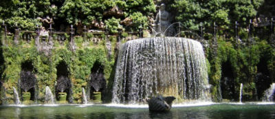
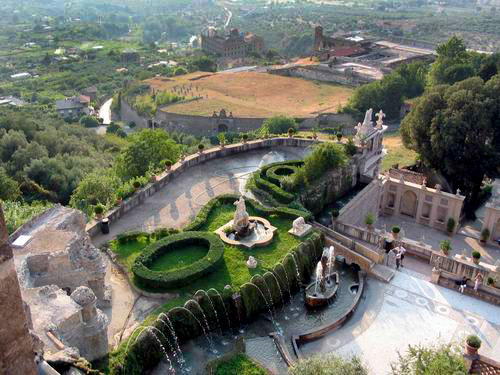
There is so much beauty to see in the gardens of Villa d’Este that will definitely leave you breathless and looking for more. Explore the magnificent landscape of the different plants and fountains that adorn the wide garden. There are about more than five hundred fountains and statues that will satisfy your artsy inclinations and may even teach you a thing or two on how the Romans defined the word beauty through their art form.

If you’re staying in Rome, you can arrange for a day trip to Villa d’Este via your booking agent or the villa’s touring office. You can either rent your own car or take the Roma – Pescara Train line from the Tiburtina Station all the way to the Tivoli Station. Once you’re in Tivoli, it’s easy to get on a bus to Villa d’Este. You can also take the Blue Cotral bus from Rome straight to Tivoli for an hour bus ride and don’t forget to take a few pictures of the sights along the way.

You will realize that the trip to Villa d’Este is definitely worth to take once you get a glimpse of the world renowned Fountain of the Hydraulic Organ or the Fontana dell’Organo Idraulico. Its dazzling waterworks and intricate carvings make it truly an artwork of beauty and ingenuity to behold.


Villa d'Este
Villa d’Este
The Villa was built in 1550

Aniwa

Aniwa

Aniwais a small island in the southernmost point of the Tafea Province. Rising merely 42 meters above sea level, the island is actually a raised coral atoll island. In the northwest, you can find the Itcharo Lagoon that is open to sea.

Aniwa has five main islands:Itamotou, Isavai, Imale, Ikaokao, andNamsafoura. The main village Ikaokao is located in the southern area of the island.

The island is a Polynesian outlier. Its current inhabitants were originally from Samoa, people from the Wallies and Futuna group as compared to Melanesian people from other nearby islands. There is however much inter-marriage with Tanna over several generations. The inhabitants of the islands speak Futunan.

Things to See and Do

Aniwa is a place that offers you a lot of things to do and it’s all up to you. This place is for people who crave adventure.

Diving– the archipelago has one of the most accessible dive sites in the South Pacific. The warm harbor, coral reefs, shipwrecks, drop offs and caves make diving an unforgettable experience. Diving in Vanuatu provides excellent visibility all year round. Snorkelling is also another fun activity to do, since the rich playground of coral reefs and abundant marine life is present all over Vanuatu’s coastal waters.

Wildlife– go sightseeing and check the country’s beautiful butterflies, exotic birds and other more exotic animals. Go on a nature tour, bird watching or go on a bush adventure.

Volcanoes– You can visit the Mt. Yasur Volcano and walk to the crater to view its multiple vents. You will enjoy visiting it at night when you can see the fountains of erupting ash, glowing bright red against the black and starry sky.

Sea activities– one has almost unlimited possibilities to do when at the Vanuatu sea: go fishing, sailing, sightseeing, snorkelling, swimming, cave tours and more. The beaches are one of the finest found in the South Pacific! They also have magnificent black sand beaches on some volcanic islands, definitely worth a visit.

Culture– Check the islands’ diverse cultures by visiting the Vanuatu Cultural Center & Museum, where they have the interesting Custom Village Tour. Get to know the natives from the different islands as well as their art objects, rituals, dance and more.


Map Of Aniwa
Aniwa
Aniwa, WI map

Jantar Mantar Observatory in Jaipur

Jantar Mantar Observatory in Jaipur

The Jantar Mantar is an observatory located in Jaipur City, state of Rajasthan, India.

The Jantar Mantar was built by Jai Singh II (emperor of the Amber dynasty) in between the years 1727 and 1734. There are a total of five Jantar Mantar observatories of the same style built by the emperor at different places. Among the five constructions, the Jantar Mantar observatory at Jaipur is considered as the biggest of the five. In the year 1948, the Jantar Mantar observatory was stated as the National Monument.

The name “Yantra” actual word Jantar means “an instrument” and “Mantra” means “principle”, the people of Rajasthan pronounce the word “Ya” in place of “Ja”.

The Jantar Mantar was built with marble, several stones and bronze sheets; the placement of these materials is very accurate. The Jantar Mantar observatory is also known as “time machine”. It contains 14 numerical devices which are used in time measurement, approaching eclipses, discovering new planets, present condition of the planets and predicting about the outer space altitudes.

Among the devices inside the Jantar Mantar, the biggest instrument is the “Samrat Jantar”, which is about 90 feet high and faced at 27 degree latitudes to Jaipur city. The Shadow of Samrat Mantar is plotted in such a way that the time can be calculated based on the instrument. The Samrat Yantra (sundial) is also the world’s biggest sundial which calculates the accurate time of Jaipur city every two seconds. In addition there is a small dome on the top of the Samrat Jantar which predicts the seasons and eclipses.

In the present days, the Jantar Mantar observatory is a great tourist spot, the people of this city still use the Jantar Mantar for the prediction of weathers. The Jantar Mantar is also filmed in many national and international films and has become a great spot for shooting films.

Traveling to Jantar Mantar observatory
The Jantar Mantar opens at 9:00am in the morning and closes 4:30pm in the evening.
Jaipur being the capital city of Rajasthan state and also second largest tourist spot in India is well connected with all the parts of the country. In addition there are several bus services from all the parts of Rajasthan state. People traveling there can choose their means of transport according to their interest.


Jantar Mantar observatory
Jantar Mantar Observatory in Jaipur
Jantar Mantar Observatory

Lake District of Argentina

Lake District of Argentina

The Lake District of Argentina stretches from the town of Junin de los Andes in the north to Cholila in the south. As the name suggests, this region has around twenty lakes where the largest is Nahuel Huapi on the shores of Bariloche.

Almost all nature-oriented activities are offered in the towns located in the Lake District. Visitors can go trekking, skiing, kayaking, rock climbing, and fishing. Fishing is especially popular among tourists who go there to for the ultimate Patagonia fishing experience. This is one of Argentina’s most popular tourist destinations with thousands of visitors coming every year.

The towns scattered around the Lake District provide travelers with many options for accommodations and adventures in addition to arranging expeditions for fishing and hiking in the mountains. The largest town is Neuquen. It acts as a hub for transportation in and out of the region. At the town’s outskirts are paleontological sites and wineries. For those who are into outdoor activities, it is best to set up camp in Bariloche. It is also the starting point for those who wish to go further to southern Patagonia and Chile. Backpackers often flock to El Bolson. Nature lovers will feel right at home here as vegetarian foods, sweets, and jams are made from local produce. The lakeside villages of Villa Traful and San Martin de los Andes are also worthy of a quick visit. The northern part of Chos Malal offers visitors the chance to explore volcanoes, lagoons, and hot springs.

Locals visit the Lake District in July and August for skiing holidays, while January is the top month for aquatic activities in the lakes and hiking in the mountains.


Argentina - Lake district near
Lake District of Argentina
Angostura. Lake District

Azerbaijan

Azerbaijan

Formally referred to as the Republic of Azerbaijan, this country is located in Eurasia’s Caucasus Region, flanking Eastern Europe and Western Asia. This is the reason why Azerbaijan is having an identity crisis. It is almost Europe but is also Asia, and this contradiction of sorts is what makes the country distinct from its neighbors.

In Azerbaijan, the ancient age of historical empires coexist with post-Soviet Union optimism. The center of the nation is its capital Baku. This is where the action is, so to speak. The petroleum-fueled wealth is on display 24/7 with black limousines and skyscrapers dominating the city. At its center, however, is a UNESCO historical site. A three-hour drive takes you to local villages teeming with green orchards with the Caucasus Mountains as their backdrop. Here, one will feel the striking contrast of laidback country life against Baku’s fast-paced city life. Cattle replace the limos and teahouse terraces edge out skyscrapers.

If you want to get the best experience from your Azerbaijan trip, it is advisable to go there anytime between April and June. At this time of the year, the skies are bright and the land is lush with flora. If you fail to book within the period, try October, especially if you are all for exploring Baku and not so keen on getting a taste of the countryside. There is not much to see there except brown earth.

When it comes to safety issues, it helps to know that Azerbaijan is a safe country for tourists. The locals are generally helpful but also inquisitive. Be prepared to answer a few personal questions.


Map - Azerbaijan
Azerbaijan
Azerbaijan travel guide -

Sagarmatha National Park

Sagarmatha National Park

Sagarmatha National Park is found in the eastern part of Nepal. It has both parts of the southern half of Mount Everest and of the Himalayas. The park was established July 19, 1976 and was inscribed as a National World Heritage Site in 1979. Sagarmatha originated from the Sanskrit word sagar which means sky and matha which means head or forehead. Currently, the famous Sagarmatha is known as the Mount Everest.

The area covers roughly around 1,148km square and ranges an elevation from its lowest peak of 2,845 at Jorsalle to 8,850m or 29,035 feet at the Everest Summit. Barren is a land 5,000m or 16,400feet. It is composed of 69% park, 28% grazing land and 3% forest. Because of the rising altitude, this park can be divided into four climate zones namely forested lower zone, alpine zone, the upper alpine zone which includes vegetation growth and the Arctic zone where no plants can live or survive.

The park visitor center is seen at the top of the hill located in Namche Bazaar the same place where Nepal Army is stationed to protect the park. The southern entrance can be found a few hundred meters north of Mondzo. Roughly around a day hike from Lukla.

Sagarmatha National Park is known to be the highest national park in the world. Located nearby are peaks of Lhotse, Thamerku, Ama Dablam, Kwangde, Pumori, cho Oyu, Kangtaiga and Gyachyung Kang. It was reported that more that 118 species of birds and 26 species of butterflies resides at this place. Among the endangered species that can be found or seen in this place are Wild Yak, Musk Deer, Snow Leopard, Red Panda and the Himalayan Black Deer. The best seasons to visit this place are during the month of October to November and December to February.

It was said that nothing can match the walker’s sense of thrill and excitement when they explore Sagarmatha National Park by foot.


Sagarmatha National Park

Moroccan Dirham

Moroccan Dirham

The Moroccan Dirham is the official currency in the country of Morocco with currency code MAD. Issuance of the Dirham is done by the Bank Al-Maghrin, the Morocco’s central bank.

Historically, the Dirham originated from the Byzantine Empire’s Drachm and circulated in Arabia and the Levant during pre-Islamic times. The name “Dirham” comes from the Roman word “Denarius” which was a currency used during the Roman period. Before 1882 Morocco’s currency consisted of copper coins in Falus denomination, silver coins which are called Dirham, and Benduqi gold coins. Starting 1882 Morocco adopted the Rial as its official currency and Dirham became its fraction with 1 Rial = 10 Dirham. Reintroduction of the Dirham came in 1960 replacing the Franc as a major currency after the French controlled most of Moroccan territories from 1904 to 1956. However, circulation of the Franc continued with 1 Dirham = 100 Francs. By 1974, the Centime replaced the Franc.

The Dirham coin denomination consists of 1, 5, 10, 20 centimes and ½, 1, 2, 5, and 10 dirham. The 1 centime is made up of aluminum and the 5-20 centimes are made from brass. The ½ to 2 dirham coins are composed of cupronickel; while the 5 and 10 dirham are ringed bi-metallic made up of cupronickel and brass for the 5 dirham and aluminum bronze and cupronickel for the 10. Banknotes consist of 10, 20, 50, 100, and 200 dirham. A US dollar is approximately around 8.13 at present ratings.

The exchange of the Moroccan Dirham appears quite simple and straightforward but visitors and tourists to this country get confused at times with the wide acceptance of the Rial as a monetary unit. The Rial, though not official, is still popularly expressed by many. Rial is used when speaking in Arabic while the Centime when speaking in French. In most parts of the country, the exchange is like this: a Dirham is equal to 20 Rials. In the City of Tangier, though, and the Rif region located in the northern part of Morocco, only 2 Rials is equivalent to the Dirham. There is no set exchange rate or standard for the Rial. And what’s more confusing, the Centimes are at times called Francs or Pesetas in some parts.


ON AUCTION 50 MOROCCAN DIRHAMS
Moroccan Dirham
100 Moroccan Dirhams

Troy

Troy

A short lesson in history and a review of Greek mythology, you will find that Troy plays an important role in shaping history. Even before a movie was made, Troy already has been popular among travelers. Today, the Ruins of Troy houses imposing structures that would take your breathe away.

Going back in history, the Troy Ruins will allow one to think about the Trojan War that went on for years. Hailing Helen as “the face that launched a thousand ships”, the war sparked a number of significant events that shaped the course of history.

Today, the city that has existed for over 4,000 years displays the skills developed during the ancient times. Charles McLaren first discovered the Troy Ruins in 1822, and later on, Heinrich Schliemann spearheaded the excavation between 1870 and 1890. An excavation in 1988 supported the claim that a battle ensued in the city, as archeologists found evidence of such a battle, among them arrowheads in the site.

A visit to the Troy Ruins will bring you face to face with a replica of the Trojan horse, which was a supposed gift from the Greeks; the token led to one great battle. This is a favorite spot among visitors, as the horse provides a perfect backdrop for a photo opportunity.

The archeological site of the Troy Ruins welcomes visitors coming from Istanbul by bus, or from Canakkale, by ferry. Officially called Troia by the Turkish government, the site now features several shops and a museum. The recent years saw the greater concern to protect the site, as looting and destruction of important structures transpired in the earlier years.

Guided tours to the site are available, and availing of such would enrich one’s visit to the site. More than visiting a place that holds great importance in history, a visitor would bask in the good feeling that he or she has learned something new.


Map of Troy and its major thoroughfares
Troy
Helen of Troy

Masindi

Masindi

Uganda is an interesting country despite its persistent poverty and food supply problems. There are a great number of tourist attractions that you can visit in Uganda to broaden your cultural outlook. Try going rustic for a change and mingle with the natives of Uganda in Masindi. Masindi is a small town located at the northwestern section of Uganda. You can get to Masindi from the main road leading out of the country’s capital city of Kampala. Tourists can spend the night at the Masindi Hotel, the oldest hotel in Uganda. The Masindi Hotel has been in operation since 1923. You can get a feel of native activity in the bustling Masindi Market Street on a Sunday morning. The market, however, can get to be quite congested so you have to make sure that you are comfortably attired for hot and humid Masindi. Don’t forget to carry your own drinking water to ensure that you are fully hydrated at all times.

There is an airport right in Masindi that services the air transport needs of this small town. The presence of the Butiaba Port provides additional access to Masindi. Also in this small town are notable landmarks like the Kinyara Sugar Works which is one of only three major sugar manufacturers in entire Uganda. Several nature parks are also available for tourist visits in Masidi. Among these are the Murchison Falls National Park, the Budongo Forest Reserve, and the Bugungu Wildlife Reserve. The Omukama’s Masindi Palace is also located in this quaint town. Only a few banks are located in this small town so you have to make sure that you have enough local currency on you when you visit Masindi.


Photo from Masindi, Uganda
Masindi
Masindi Location Map

Kenting National Park

Kenting National Park

Kenting National Park is divided into the north and south by the Hegchun valley plain. It was established on the first day of 1984 and is Taiwan’s first national park.

You can find it in Hengchun, Pintung County. It contains a vast number of Taiwan’s population and its size of 333 square kilometer includes 181 square kilometers of land. It consists of a variety of animal species which will bring enthusiasm into the hearts of this world’s animal lovers. The vast number of species includes 310 kinds of birds, 216 types of butterflies, 21 kinds of freshwater fish and various species of mammals, reptiles and amphibians. The place also owns a series of bedazzling landscapes which extend from the north to the south. The movement of the crust is mirrored through its topography and has caused much movement on the peninsula which makes everything very interesting for geologists.

Worldwide, Kenting National Park is actually known as the haven for water lovers because of its beautiful sea. It is really the epitome of a heavenly paradise. Aside from the many kinds of animals, you can also find here various species of endangered plants-including the Taiwanese orchids. Going here will assure you a good chance for recreational activities, and a providence of luxury, relaxation and pleasure. You are sure to enjoy here the enchantments of its natural resources.


Kenting National Park - ,
Kenting National Park
Kending (Kenting) National

Irkutsk

Irkutsk

Irkutskis one of Siberia’s largest cities. It is the heart of the administration of Irkutsk Oblast, located 3,222 miles by rail from the Russian capital, Moscow. It grew out of Yakov Pokhabov’s established winter quarters for gold trading and fur tax collecting in 1652, and became an official city in 1686. Its population is around 600,000.

Being a Siberian city, Irkutsk has a sub arctic climate. The temperatures between seasons fluctuates to and from extremes; summers can be very warm while winters brutally cold. If the temperatures aren’t as extreme in other parts of Siberia, it’s because of Lake Baikal.

Irkutsk offers many sights to see, such as the Epiphany Cathedral, the crown factories, and the governor’s palace. There’s also the Alexander Kolchak monument, which was designed by Vyacheslav Klykov and unveiled in 2004. If museums are your thing, you can step into the Taltsy Museum, an open-air museum to where a number of old wooden buildings from Angara valley’s villages have been transported and reassembled after the post-construction flooding of the Ust-Ilimsk and Bratsk Dams. Also nice to know, although you may not be able to visit the place, is that Valentin Rasputin, well-known Russian writer, resides in Irkutsk.

As with most, if not all cities, transportation to and around Irkutsk is convenient. The Trans-Siberian Railway and other important roads and rails connect the city to other Russian and Mongolian regions. There are also the Irkutsk International Airport and Irkutsk Northwest Airports to serve your flying needs.

A nation that’s not only big in territory but also in name due to its being a major world power is not a place as romanticized, as say, France or England. You might be lured to Paris, France for its beautiful cafes whose exteriors give you a view of the magnificent Eiffel Tower; or London, England for its foggy nights through which the beautiful city lights pierce; or Venice, Italy for its pizzerias and wonderful cuisine and the exciting boat rides via its canals. But you might never think, “Hey, I’d like to visit Russia one day and sit on a park bench appreciating the view of my surroundings.” Maybe it’s their language; maybe it’s the potentially grueling cross-country journey you might have to take should you be the type that wants to see entirety of a place you’re visiting. Either way, give Russia a chance. And maybe you can start with Irkutsk.


Irkutsk, Russia | Source
Irkutsk
Irkutsk Scientific Centre

Te Anau

Te Anau

Thinking about a great nature getaway? Well, why don’t you try and experience a trip to the“Walking Capital of the World.” Here inTe Anau, New Zealand, feel free to experience the works of nature in slow motion.

So, what’s with walking, anyway? To start with, the walking tracks offered by Te Anau will give you a sense of freedom in your travel. You get to experience nature as fast or as slow as you wish it to be. Here, you will come face to face with your discoveries of snowcapped mountain peaks, rain forests, tussok clad alpine plateaus, and all the other offers of nature. You can choose to get a tour guide or grab a paper guide for you and your own team to discover yourself any walking track in Te Anau.

On these walking tracks, you can find along the way some of the most magnificent parks of Te Anau. You can see Wildlife Park, Ivon Wilson Park, and Dock Bay. In both parks you will find a variety of birds, like the parakeet, the kea, tui, kaka, takahe, and waterfowl within the mountains and a lake in the background. On the other hand, you can pack up a great picnic or swimming trip once you are at the Dock Bay.

Aside from the great walking adventures, Te Anau also offers one unique cave for tourists like you. You can visit the Te Anau Glowworm Cave, which is one of a kind in the whole of the Southern Hemisphere. The journey to this cave alone is already exciting. You must ride a boat for thirty minutes on a lake to get there.

More than pleasing your eyes with the various sights here in Te Anau, you can have more adventures here other than walking. You can experience scenic flights, sea kayaking, boat cruises, underwater diving, fishing, and cycling as well. Indeed, there will always be one activity here that will suit your personality and adventure level.

Here’s an added treat for you here in Te Anau. Just like any other cities in New Zealand, the place is also home to a lot of fine restaurants where large selections of the country’s best wines are housed. You can always relax from the sightseeing and physical adventures this place has to offer in exchange for a good sip of some of the world’s best wines. Indeed, Te Anau is more than just the “Walking Capital of the World.”


Te Anau Lakeview Holiday Park
Te Anau
Milford Sound Te Anau Top Ten

Mahabalipuram Temples

Mahabalipuram Temples

The Mahabalipuram temples are located in the Mahabalipuram town, in the state of Tamilnadu, India. From Chennai (the capital city of the Tamilnadu State) Mahabalipuram is about 58 km.

The actual name of Mahabalipuram is “Mamallapuram” which was kept in the honor of the King Narasimha Varman I, king of the Pallava Dynasty, who has built the ancient monuments in Mahabalipuram. However, the place became popular as “Mahabalipuram” or the “Bali City”, which means sacrifice.

The Mahabalipuram has the history of about 2,000 years back, where almost forty monuments are inscribed. Mahabalipuram has become a great pilgrimage place since the 1st century attracting a large number of scholars and foreigners from all over the world.

Mahabalipuram is famous for its temples and its architecture; some of the major temples are listed below

Temples at the Shore
During the past, there are three major temples at the Bay of Bengal shore. The first temple is “Vaishnava”, which is devoted to Lord Anantasayi. The temple and the idol of Lord Anantasayi are made with a massive rock. The Saiva and Vimanas are the other temples, but these temples vanished over the years.

The Shore Temple
The Shore Temple is located to the edge of Bay of Bengal. The tides entered into the walls of the temple since 13th century. However, a single structure has not sunk in the water over the centuries.

Sthalasayana Perumal Temple
The Vijayanagar Dynasty emperors have built the Sthalasayana Perumal Temple. The Sthalasayana Perumal Temple lies on the edge of the sea. To the west of Sthalasayana Perumal Temple, five Rathas (chariots) are located, where the deity of the temple will be placed on the Rathas on festivals.

Events at the Temples
Every year the Tamilnadu government organizes the “Mahabalipuram Dance Festival”, which starts on 25th December and ends on first week of February. This festival describes about the ancient history of traditions of the Pallava Kings.
In addition, a number of dance festivals and music competitions are conducted, where musicians and dancers from all the country take part in it. Among the events Kuchipudi, Bharathanatyam, and folk dances are a special attraction.
Traveling to Mahabalipuram:

Mahabalipuram being a pilgrimage place, is connected with all means of transport.

Chennai International Airport is the nearby airport. Chennai being the capital city of the Tamilnadu state is well connected with all the parts of India and all regions of the world.

Chegalpattu is the nearby railway station, which is about 29 km, frequent train services are available from Chennai.

Frequent bus services are available from all the regions of Tamilnadu.


Mahabalipuram Temple
Mahabalipuram Temples
Mahabalipuram Temple Photo

Grace Cathedral

Grace Cathedral

It is never too late to be one with your faith no matter what congregation you belong to. At the San Francisco’sGrace Cathedral, all sects are welcome to have a quiet and serene moment any time of the day. This is one of the tourist spots that every traveler must include in their itinerary. There are several places to explore and one of the more popular ones is the labyrinth. Although there are some religions that prohibit them to enter a place of worship aside from their own, the Grace Cathedral also has art collections that are truly hard to resist.

In the Cathedral, several collections that date back centuries are for everyone to see. Once the pipes of the organ are played, the music will draw flocks of believers into the cathedral. Children are also welcome to enter since any place of worship has nice and spacious grounds for them to run around. Let them enter the cathedral but make sure that they are to keep silent at all times. The grounds are indeed a place for fun too since they can play there while you pray inside. Keep an eye on them while you pray or better yet, have a designated guardian to watch over them so they will not wander off too far when you’re not looking.

It is suggested to visit at noon even though it opens as early as seven in the morning on weekdays. San Francisco is known for chilly mornings, so it is recommended to go touring when the sun is already up and shining so you need not layer your clothes that much. When you are inside the cathedral, you might want to look up to check out all the intricate paintings and designs all over the church’s ceiling.


Grace Cathedral, San Francisco
Grace Cathedral
Grace Cathedral, California

Sihanoukville

Sihanoukville

Sihanoukville Cambodia is home to white sand beaches, exclusive beach towns, breath taking islands and warm tropical waters. A very popular tourist destination that is surrounded by Thailand’s bay, Sihanoukville is not only famous for its tropical attractions but also for its world-class beach hotels and resorts. This place offers fantastic beach spots and a very inspiring culture. Accommodations here are also affordable and hundreds of vacation activities can be experienced around the town. Sihanoukville, before transforming into a well known tourist spot, this province was first founded as a port town. But because of its white sand beaches, the whole province of Sihanouville quickly grew into a popular beach destination for both locals and tourists.

Most of today’s major roads in and out of Sihanoukville Cambodia are now in good condition. They also have 24/7 regularly scheduled air-con buses for easy traveling connecting to other coastal cities such as Koh Kong, Kep and Kampot each with their own unique beauty.

Its port city is also a very nice place to visit that offers a number of things that can be done which are very fulfilling. These activities include bargain shopping and night market shopping. Its nightlife is also fabulous and very indulging.

The primary recreation spot in Sihanoukville Cambodia is their beaches but aside from these, a wide variety of sports can also be played in Sihanoukville. Play tennis, volleyball or even football, Sihanoukville has them all. In addition to these recreational activities, some of its popular water sports also include snorkeling and scuba diving. Visiting Buddhist temples and mountain hiking are also exciting while in Sihanoukville.


Sihanoukville, Best Beach in
Sihanoukville
Sihanoukville's beaches have

Comino

Comino

Comino is an island situated in between Malta and Gozo. It is the site of the fortress of the Hospitallers. It is a small island which makes it intimate and easy to navigate.

Comino is the best place to relax. The only means to reach it is to ride a small ferry that departs in ÄŠirkewwa. There are only a few cars in Comino which means that there is no traffic at all.

Snorkeling and scuba diving are among the most enjoyable things to do in Comino. There are many places where it is recommended to swim, snorkel, and dive. Although the things that you can do in Comino are very limited, you can still enjoy a relaxing vacation because of the spectacular views of the island.

There are three main beaches in Comino: theBlue Lagoon, theSt. Mary’s Bay, andSt. Nicholas Bay.

If you are planning to see Comino and all the wonderful places that this island has to offer, here are some suggestions:

The Blue Lagoon. It is a very popular spot to dive, snorkel, and swim because of the clear waters and white sand. It offers a breathtaking sight that you wouldn’t want to miss.

St. Mary’s Tower. This is a watchtower that has gained much of its popularity as the setting of the movie, “The Count of Monte Cristo.” It watches along the island and the beach from the southeastern side of the island.

St. Mary’s Chapel.It is a church dedicated to the return of Our Lady of Egypt. It was first built in 1618 and has undergone several restorations ever since.

St. Nicholas and St. Mary’s Bay.
The other two beaches in the island. Provides great view for tourists and is also a good place for scuba diving and snorkeling.


Island of Comino
Comino
Comino

Planes of Fame Air Museum

Planes of Fame Air Museum

Museums are supposed to be large, stuffy, and closed halls filled with dusty artifacts, old paintings, and untouchable exhibits. Don’t expect any of that in this extraordinary showcase of the wonders of flight.

ThePlanes of Fame Air Museumcan be found mainly in Chino, California, but the huge collection of flyable – yes, at least 30 are flyable and flown during the museum’s monthly and annual air shows – and exhibit aircraft it has assembled over the years has caused it to open another facility in Valle, Arizona in 1995, containing over 40 aircraft.

First opened in 1957, the museum was then known simply as “The Air Museum”. Volunteers recovered aircraft which would have otherwise been scrapped or melted down and set out to make these flyable once again. The museum’s collection grew over the years and it moved a lot until it finally settled at the Chino Airport in California in the 1970s.

Visitors to the museum at either Chino or Valle will be able to see a huge collection of airplanes – both restored and unrestored – from the First World War, the Second World War, and on to the jet age. There are also a few military ground vehicles such as tanks on display. Some of the aircraft and vehicles of the museum have also appeared in movies like Pearl Harbor. They have also been shown on television and featured in books.

As an added treat, members of the museum are allowed to take up a few of the aircraft on “orientation flights” and experience firsthand what it actually felt like to be in the cockpit of a famous aircraft. Who wouldn’t want to actually go up in a Dauntless dive bomber or race through the sky in a P-51 Mustang or shoot for the stars in a T-33 Shooting Star jet plane? This is the place to go for anyone who ever dreamt of flying.


Planes of Fame Air Museum's Lockheed P-38J-20-LO Lightning
Planes of Fame Air Museum